IMAGES TAKEN NEAR TO
Denbigh Avenue, GILLINGHAM, ME8 7HA
Introduction
This page details the photographs taken nearby to Denbigh Avenue, ME8 7HA by members of the Geograph project.
The Geograph project started in 2005 with the aim of publishing, organising and preserving representative images for every square kilometre of Great Britain, Ireland and the Isle of Man.

There are currently over 7.5m images from over14,400 individuals and you can help contribute to the project by visiting https://www.geograph.org.uk
Image Map (Loading...)


Getting Data...Please wait
Leaflet Map data © OpenStreetMap
Images are licensed for reuse under creativecommons.org/licenses/by-sa/2.0
Notes
- Clicking on the map will re-center to the selected point.
- The higher the marker number, the further away the image location is from the centre of the postcode.
Image Listing (47 Images Found)
Images are licensed for reuse under creativecommons.org/licenses/by-sa/2.0
Image
Details
Distance
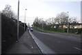
4

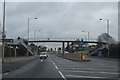
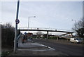
Footbridge over London Road (A2)
Looking towards Bloors Lane junction. A2 then goes on to Rainham.
Footbridge takes children to playing fields and The Howard School on Salisbury Avenue, to the right of the photo.
Image: © David Anstiss
Taken: 8 Nov 2008
0.05 miles
8

Walkway to football pitch
This leads from Image to a school football pitch.
Only open on school days.
Image: © David Anstiss
Taken: 14 Dec 2013
0.06 miles