IMAGES TAKEN NEAR TO
Bloomfields, GILLINGHAM, ME8 7BZ
Introduction
This page details the photographs taken nearby to Bloomfields, ME8 7BZ by members of the Geograph project.
The Geograph project started in 2005 with the aim of publishing, organising and preserving representative images for every square kilometre of Great Britain, Ireland and the Isle of Man.

There are currently over 7.5m images from over14,400 individuals and you can help contribute to the project by visiting https://www.geograph.org.uk
Image Map (Loading...)


Getting Data...Please wait
Leaflet Map data © OpenStreetMap
Images are licensed for reuse under creativecommons.org/licenses/by-sa/2.0
Notes
- Clicking on the map will re-center to the selected point.
- The higher the marker number, the further away the image location is from the centre of the postcode.
Image Listing (31 Images Found)
Images are licensed for reuse under creativecommons.org/licenses/by-sa/2.0
Image
Details
Distance
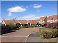

7

Macklands House, Rainham
Macklands House in Rainham is a retirement housing complex built in 1981. It is on a much older site and the Ordnance Survey Map from before the First World War shows Macklands with a tramway running immediately to the north -
https://maps.nls.uk/geo/explore/#zoom=17.2&lat=51.37153&lon=0.61958&layers=168&b=1&o=100
Image: © Marathon
Taken: 27 Jun 2024
0.12 miles
8

Macklands House, Rainham
Macklands House in Rainham is a retirement housing complex built in 1981. It is on a much older site and the Ordnance Survey Map from before the First World War shows Macklands with a tramway running immediately to the north -
https://maps.nls.uk/geo/explore/#zoom=17.2&lat=51.37153&lon=0.61958&layers=168&b=1&o=100
Image: © Marathon
Taken: 27 Jun 2024
0.12 miles
9
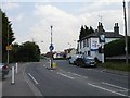
The Angel, Lower Rainham
The pub stands on the junction of Station Road with Lower Rainham Road, a junction now regulated by the ubiquitous mini-roundabout. The flag of St George is on display because of the football World Cup.
Image: © Penny Mayes
Taken: 16 Jun 2006
0.12 miles
10
Starlings in Rainham
This scene looked like something out of 'The Birds'.
Image: © Marathon
Taken: 29 Aug 2022
0.14 miles