IMAGES TAKEN NEAR TO
Ripon Close, GILLINGHAM, ME8 7BS
Introduction
This page details the photographs taken nearby to Ripon Close, ME8 7BS by members of the Geograph project.
The Geograph project started in 2005 with the aim of publishing, organising and preserving representative images for every square kilometre of Great Britain, Ireland and the Isle of Man.

There are currently over 7.5m images from over14,400 individuals and you can help contribute to the project by visiting https://www.geograph.org.uk
Image Map (Loading...)


Getting Data...Please wait
Leaflet Map data © OpenStreetMap
Images are licensed for reuse under creativecommons.org/licenses/by-sa/2.0
Notes
- Clicking on the map will re-center to the selected point.
- The higher the marker number, the further away the image location is from the centre of the postcode.
Image Listing (33 Images Found)
Images are licensed for reuse under creativecommons.org/licenses/by-sa/2.0
Image
Details
Distance

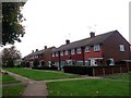
4

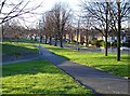
Pump Lane, Twydall
Pump Lane runs down from the A2 to the Lower Road, passing through Twydall (pronounced twiddle) on a staggered junction across Beechings Way before passing under the railway. The railway bridge is just visible here and the railway forms the boundary of modern housing development.
Image: © Penny Mayes
Taken: 18 Mar 2007
0.06 miles

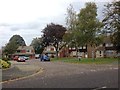
9
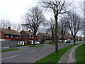
Beechings Way, Twydall
From the corner of Pump Lane. Twydall is pronounced twiddle.
Image: © Penny Mayes
Taken: 18 Mar 2007
0.12 miles