IMAGES TAKEN NEAR TO
Wright Close, GILLINGHAM, ME8 6XP
Introduction
This page details the photographs taken nearby to Wright Close, ME8 6XP by members of the Geograph project.
The Geograph project started in 2005 with the aim of publishing, organising and preserving representative images for every square kilometre of Great Britain, Ireland and the Isle of Man.

There are currently over 7.5m images from over14,400 individuals and you can help contribute to the project by visiting https://www.geograph.org.uk
Image Map (Loading...)


Getting Data...Please wait
Leaflet Map data © OpenStreetMap
Images are licensed for reuse under creativecommons.org/licenses/by-sa/2.0
Notes
- Clicking on the map will re-center to the selected point.
- The higher the marker number, the further away the image location is from the centre of the postcode.
Image Listing (47 Images Found)
Images are licensed for reuse under creativecommons.org/licenses/by-sa/2.0
Image
Details
Distance
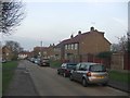
1
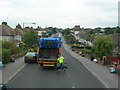
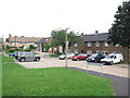
Begonia Avenue, Twydall
It is a Tuesday, the bins are emptied today. This cart is picking up black rubbish bags, a different cart will come round for the blue recycling boxes and bags.
Image: © Danny P Robinson
Taken: 15 Jul 2008
0.01 miles
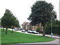
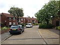
8
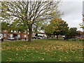
Woodchurch Crescent Play Area
Also known as Sturry Way Park, this view is from Romany Road with Sturry Way on the left.
Image: © Marathon
Taken: 29 Oct 2024
0.10 miles