IMAGES TAKEN NEAR TO
South Avenue, GILLINGHAM, ME8 6EG
Introduction
This page details the photographs taken nearby to South Avenue, ME8 6EG by members of the Geograph project.
The Geograph project started in 2005 with the aim of publishing, organising and preserving representative images for every square kilometre of Great Britain, Ireland and the Isle of Man.

There are currently over 7.5m images from over14,400 individuals and you can help contribute to the project by visiting https://www.geograph.org.uk
Image Map (Loading...)


Getting Data...Please wait
Leaflet Map data © OpenStreetMap
Images are licensed for reuse under creativecommons.org/licenses/by-sa/2.0
Notes
- Clicking on the map will re-center to the selected point.
- The higher the marker number, the further away the image location is from the centre of the postcode.
Image Listing (61 Images Found)
Images are licensed for reuse under creativecommons.org/licenses/by-sa/2.0
Image
Details
Distance

4
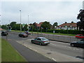
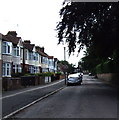
Sovereign Boulevard, Gillingham
This is the A2, the spine route through the Medway area. With houses on South Avenue in the background.
Image: © Danny P Robinson
Taken: 15 Jul 2008
0.06 miles
5
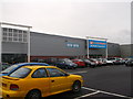
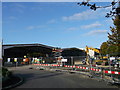
Family Bargains, Gillingham
Within the Gillingham Business Park.
This store has recently opened. It was once used by the MFI Store.
It is now a bargain store related to Poundland group.
Image: © David Anstiss
Taken: 23 Dec 2012
0.07 miles

8
Construction site in Gillingham Business Park
These former sheds on Ambley Road were once used by the MFI Store.
It is rumoured they are now being converted by the Thistle Construction into a cheap food store connected to Poundland.
Image: © David Anstiss
Taken: 10 Oct 2012
0.08 miles
9
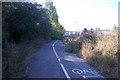
Footpath and cyclepath to B and Q Store
This path lead of the A2 Watling Street dual carriageway. Store is on the right.
Image: © David Anstiss
Taken: 24 Sep 2009
0.09 miles
10
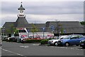
Medway - the 'Tesco roundabout'
This image was taken in Medway next to where the A278 meets the A2 (the old Canterbury to London road). The junction is known as the 'Tesco roundabout'.
Image: © David Rayner
Taken: 17 May 2005
0.09 miles