IMAGES TAKEN NEAR TO
Lawrence Street, GILLINGHAM, ME7 5TY
Introduction
This page details the photographs taken nearby to Lawrence Street, ME7 5TY by members of the Geograph project.
The Geograph project started in 2005 with the aim of publishing, organising and preserving representative images for every square kilometre of Great Britain, Ireland and the Isle of Man.

There are currently over 7.5m images from over14,400 individuals and you can help contribute to the project by visiting https://www.geograph.org.uk
Image Map (Loading...)


Getting Data...Please wait
Leaflet Map data © OpenStreetMap
Images are licensed for reuse under creativecommons.org/licenses/by-sa/2.0
Notes
- Clicking on the map will re-center to the selected point.
- The higher the marker number, the further away the image location is from the centre of the postcode.
Image Listing (351 Images Found)
Images are licensed for reuse under creativecommons.org/licenses/by-sa/2.0
Image
Details
Distance

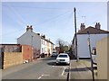

6
Dawes Street, Gillingham
This cul-de-sac street leads from Canterbury Street, to garages along the edge of the railway line (near the tree, in the background).
Image: © David Anstiss
Taken: 16 Jul 2009
0.04 miles
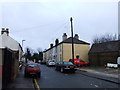
7
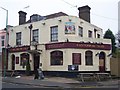
Canterbury Tales Public House, Gillingham
On junction of (99) Canterbury Street and Paget Street.
Image: © David Anstiss
Taken: 17 Nov 2008
0.05 miles

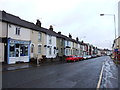
9
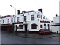
Canterbury Tales, Gillingham
Formerly known as the Woodlands Tavern.
Image: © Chris Whippet
Taken: 26 Jan 2014
0.05 miles
