IMAGES TAKEN NEAR TO
Saxton Street, GILLINGHAM, ME7 5TW
Introduction
This page details the photographs taken nearby to Saxton Street, ME7 5TW by members of the Geograph project.
The Geograph project started in 2005 with the aim of publishing, organising and preserving representative images for every square kilometre of Great Britain, Ireland and the Isle of Man.

There are currently over 7.5m images from over14,400 individuals and you can help contribute to the project by visiting https://www.geograph.org.uk
Image Map (Loading...)


Getting Data...Please wait
Leaflet Map data © OpenStreetMap
Images are licensed for reuse under creativecommons.org/licenses/by-sa/2.0
Notes
- Clicking on the map will re-center to the selected point.
- The higher the marker number, the further away the image location is from the centre of the postcode.
Image Listing (422 Images Found)
Images are licensed for reuse under creativecommons.org/licenses/by-sa/2.0
Image
Details
Distance
1
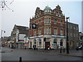
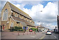
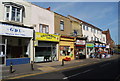
Corner of Gillingham High Street and Canterbury Street
Showing a wide variety of different building styles. The clock on the bank is incorect -- the time was about 14h45.
Image: © Danny P Robinson
Taken: 23 Dec 2007
0.01 miles
2
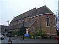
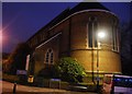
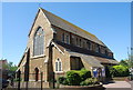
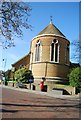
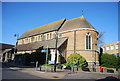
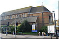
St Mark's Church, Canterbury Street, Gillingham
Picture taken at the corner of the High Street.
Image: © Danny P Robinson
Taken: 23 Dec 2007
0.01 miles