IMAGES TAKEN NEAR TO
St. Johns Road, GILLINGHAM, ME7 5QE
Introduction
This page details the photographs taken nearby to St. Johns Road, ME7 5QE by members of the Geograph project.
The Geograph project started in 2005 with the aim of publishing, organising and preserving representative images for every square kilometre of Great Britain, Ireland and the Isle of Man.

There are currently over 7.5m images from over14,400 individuals and you can help contribute to the project by visiting https://www.geograph.org.uk
Image Map
Images are licensed for reuse under creativecommons.org/licenses/by-sa/2.0
Notes
- Clicking on the map will re-center to the selected point.
- The higher the marker number, the further away the image location is from the centre of the postcode.
Image Listing (139 Images Found)
Images are licensed for reuse under creativecommons.org/licenses/by-sa/2.0
Image
Details
Distance
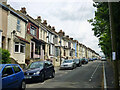
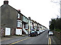
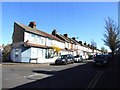
2
Imperial Road
This road leads from St John's Road, down and then back to St John's Road.
Chatham is just seen in the wintry background.
Image: © David Anstiss
Taken: 7 Jan 2010
0.04 miles
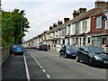
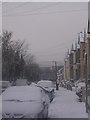
4
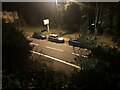
Chatham Hill at night time
Chatham Hill viewed from Imperial Road.
Image: © Clygro
Taken: 28 Dec 2021
0.04 miles