IMAGES TAKEN NEAR TO
ME7 5JT
Introduction
This page details the photographs taken nearby to ME7 5JT by members of the Geograph project.
The Geograph project started in 2005 with the aim of publishing, organising and preserving representative images for every square kilometre of Great Britain, Ireland and the Isle of Man.

There are currently over 7.5m images from over14,400 individuals and you can help contribute to the project by visiting https://www.geograph.org.uk
Image Map
Images are licensed for reuse under creativecommons.org/licenses/by-sa/2.0
Notes
- Clicking on the map will re-center to the selected point.
- The higher the marker number, the further away the image location is from the centre of the postcode.
Image Listing (90 Images Found)
Images are licensed for reuse under creativecommons.org/licenses/by-sa/2.0
Image
Details
Distance
1
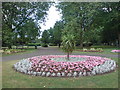
Gillingham Park (1)
Taken near the Canterbury Street entrance.
Image: © Danny P Robinson
Taken: 3 Aug 2008
0.03 miles
2
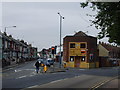
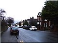
Junction of Canterbury Street and Nelson Road, Gillingham
Image: © Chris Whippet
Taken: 16 Aug 2010
0.03 miles
4
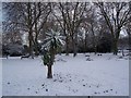
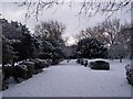
Snow covered flower borders in Gillingham Park
Compare with Image Only the Cordyline centre piece is visible. Winter bedding covered.
Image: © David Anstiss
Taken: 7 Jan 2010
0.05 miles
5
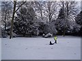
Snow Fun in Gillingham Park
A father (off work due to blocked roads) drags his daughter on a sled up slopes in the park.
Image: © David Anstiss
Taken: 7 Jan 2010
0.06 miles
6
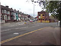
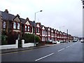
Junction of Canterbury Street and Nelson Road, Gillingham
Canterbury Street forks left and Nelson Road forks right.
Image: © Danny P Robinson
Taken: 3 Aug 2008
0.06 miles
7
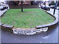
Vintage street nameplates, Napier Road and Nelson Road, Gillingham
Image: © Chris Whippet
Taken: 26 Jan 2014
0.06 miles
10
Path in Gillingham Park
This is part of a circular path around the central recreational area in the park. This is close to the entrance from Canterbury Street.
Image: © David Anstiss
Taken: 7 Jan 2010
0.09 miles