IMAGES TAKEN NEAR TO
Britton Street, GILLINGHAM, ME7 5ET
Introduction
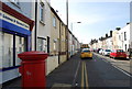
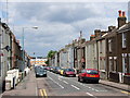
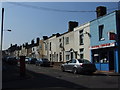
This page details the photographs taken nearby to Britton Street, ME7 5ET by members of the Geograph project.
The Geograph project started in 2005 with the aim of publishing, organising and preserving representative images for every square kilometre of Great Britain, Ireland and the Isle of Man.

There are currently over 7.5m images from over14,400 individuals and you can help contribute to the project by visiting https://www.geograph.org.uk
Image Map
Images are licensed for reuse under creativecommons.org/licenses/by-sa/2.0
Notes
- Clicking on the map will re-center to the selected point.
- The higher the marker number, the further away the image location is from the centre of the postcode.
Image Listing (370 Images Found)
Images are licensed for reuse under creativecommons.org/licenses/by-sa/2.0
Image
Details
Distance
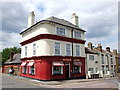
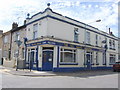
3
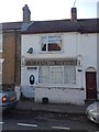
Globe & Laurel, Gillingham
Former pub (possibly the smallest in Gillingham) now a private house.
Image: © Chris Whippet
Taken: 30 Oct 2014
0.02 miles
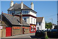
10
The Will Adams, Gillingham
Formerly known as the Anglo Saxon.
Image: © Chris Whippet
Taken: 19 Jul 2010
0.04 miles