IMAGES TAKEN NEAR TO
Stafford Street, GILLINGHAM, ME7 5EJ
Introduction
This page details the photographs taken nearby to Stafford Street, ME7 5EJ by members of the Geograph project.
The Geograph project started in 2005 with the aim of publishing, organising and preserving representative images for every square kilometre of Great Britain, Ireland and the Isle of Man.

There are currently over 7.5m images from over14,400 individuals and you can help contribute to the project by visiting https://www.geograph.org.uk
Image Map (Loading...)


Getting Data...Please wait
Leaflet Map data © OpenStreetMap
Images are licensed for reuse under creativecommons.org/licenses/by-sa/2.0
Notes
- Clicking on the map will re-center to the selected point.
- The higher the marker number, the further away the image location is from the centre of the postcode.
Image Listing (259 Images Found)
Images are licensed for reuse under creativecommons.org/licenses/by-sa/2.0
Image
Details
Distance
4
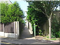
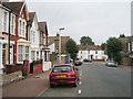
Footpath on Belmont Road
This footpath leads towards, the Great Lines Park, Upbury Manor High School and Medway Maritime Hospitals.
Image: © David Anstiss
Taken: 1 Jul 2009
0.02 miles
6
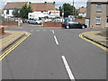
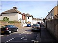
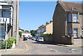
Belmont Road meets Vicarage Road, Gillingham
Belmont road leads from May Road. Vicarage Road heads left to Canterbury Road, from College Avenue.
Image: © David Anstiss
Taken: 16 Jul 2009
0.02 miles
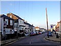
7
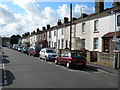
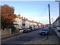
Stafford Street, Gillingham
Showing 19th century terraced housing, a very common type of housing in this area.
Image: © Danny P Robinson
Taken: 10 Aug 2008
0.02 miles