IMAGES TAKEN NEAR TO
Kings Bastion, GILLINGHAM, ME7 5BX
Introduction
This page details the photographs taken nearby to Kings Bastion, ME7 5BX by members of the Geograph project.
The Geograph project started in 2005 with the aim of publishing, organising and preserving representative images for every square kilometre of Great Britain, Ireland and the Isle of Man.

There are currently over 7.5m images from over14,400 individuals and you can help contribute to the project by visiting https://www.geograph.org.uk
Image Map
Images are licensed for reuse under creativecommons.org/licenses/by-sa/2.0
Notes
- Clicking on the map will re-center to the selected point.
- The higher the marker number, the further away the image location is from the centre of the postcode.
Image Listing (203 Images Found)
Images are licensed for reuse under creativecommons.org/licenses/by-sa/2.0
Image
Details
Distance
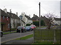
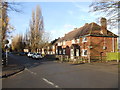
1
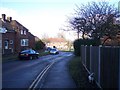
King's Bastion
This road leads from the War Memorial on the Great Lines to Sally Port Gardens.
It leads through an estate of Ministry of Defence owned housing for soldiers at the nearby army base.
Image: © David Anstiss
Taken: 4 Feb 2010
0.00 miles
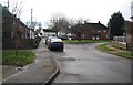
2
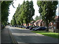
Sally Port Gardens, Brompton
Showing army housing.
Image: © Danny P Robinson
Taken: 10 Aug 2008
0.05 miles
3
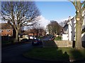
King's Bastion (2)
This small road leads off the main King's Bastion road to Sally Port Gardens.
It leads through an estate of Ministry of Defence owned housing for soldiers at the nearby army base.
Image: © David Anstiss
Taken: 4 Feb 2010
0.05 miles
4
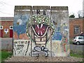
Berlin Wall
3 segments of the Berlin Wall at the Royal Engineers Museum, Gillingham, Kent UK
Image: © Silver fox
Taken: 9 Feb 2005
0.05 miles
5
Singapore Drive, Brompton
This is Ministry of Defence owned housing for soldiers at the nearby army base. The surrender of Singapore to the Japanese in 1942 was not a good time for the British so it is odd that the army named a road after the place.
Image: © Danny P Robinson
Taken: 1 Jan 2008
0.05 miles
7
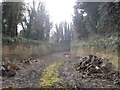
Lines behind the Lampard Centre, Brompton
The brick walls behind the garden (of the former dismantled) Lampard Centre), are part of the Napoleanoic defensive ditches (the lines) that lead from Lower Gillingham, through Brompton and then down to Fort Amherst, Chatham.
See Image This is seen through the fence in the background.
Image: © David Anstiss
Taken: 1 Mar 2013
0.06 miles
8
Lines behind the Lampard Centre
The brick walls behind the nursery garden (of the Lampard Centre), are part of the Napoleanoic defensive ditches that leads from Lower Gillingham, through Brompton and down to Fort Amherst, Chatham.
Image: © David Anstiss
Taken: 12 Oct 2012
0.06 miles
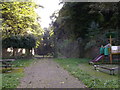
10
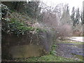
Wall behind the (former) Lampard Centre, Brompton
The brick walls behind the former children's nursery (of the Lampard Centre - now dismantled), are part of the Napoleanoic defensive ditches that leads from Lower Gillingham, through Brompton and down to Fort Amherst, Chatham.
At this point the ditch widens out for unknown reasons.
Image: © David Anstiss
Taken: 1 Mar 2013
0.07 miles