IMAGES TAKEN NEAR TO
Waterloo Road, GILLINGHAM, ME7 4SA
Introduction
This page details the photographs taken nearby to Waterloo Road, ME7 4SA by members of the Geograph project.
The Geograph project started in 2005 with the aim of publishing, organising and preserving representative images for every square kilometre of Great Britain, Ireland and the Isle of Man.

There are currently over 7.5m images from over14,400 individuals and you can help contribute to the project by visiting https://www.geograph.org.uk
Image Map
Images are licensed for reuse under creativecommons.org/licenses/by-sa/2.0
Notes
- Clicking on the map will re-center to the selected point.
- The higher the marker number, the further away the image location is from the centre of the postcode.
Image Listing (187 Images Found)
Images are licensed for reuse under creativecommons.org/licenses/by-sa/2.0
Image
Details
Distance
1
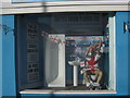
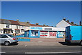
Flushed with success !!
Shop window of Plumb-fix, on the junction of Waterloo Road and Canterbury Street.
Image: © David Anstiss
Taken: 9 Jul 2010
0.03 miles
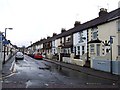
3
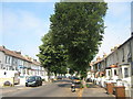
Trees on Copenhagen Road
This Aspen (populus tremula) tree lined road leads from Gillingham Road to Canterbury Road. Road also has speed bumps along the road to slow the traffic down.
Image: © David Anstiss
Taken: 1 Jul 2009
0.04 miles
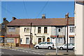
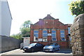
8
Gillingham Spiritualist Church
On Canterbury Street.
Image: © David Anstiss
Taken: 9 Jul 2010
0.07 miles
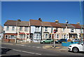
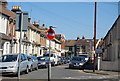
9
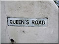
Vintage street nameplate, Queen's Road, Gillingham
Image: © Chris Whippet
Taken: 26 Jan 2014
0.07 miles