IMAGES TAKEN NEAR TO
Gillingham Road, GILLINGHAM, ME7 4EX
Introduction
This page details the photographs taken nearby to Gillingham Road, ME7 4EX by members of the Geograph project.
The Geograph project started in 2005 with the aim of publishing, organising and preserving representative images for every square kilometre of Great Britain, Ireland and the Isle of Man.

There are currently over 7.5m images from over14,400 individuals and you can help contribute to the project by visiting https://www.geograph.org.uk
Image Map
Images are licensed for reuse under creativecommons.org/licenses/by-sa/2.0
Notes
- Clicking on the map will re-center to the selected point.
- The higher the marker number, the further away the image location is from the centre of the postcode.
Image Listing (169 Images Found)
Images are licensed for reuse under creativecommons.org/licenses/by-sa/2.0
Image
Details
Distance
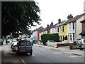
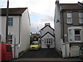
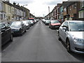
2
Road Junction on Gillingham Road, Gillingham
Gillingham Road leads from Livingstone Circus (roundabout on Barnsole and Gillingham Roads) to Nelson Road and Duncan Road traffic light junction. Beresford Road heads left towards Napier Road.
Image: © David Anstiss
Taken: 8 Jul 2009
0.04 miles
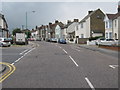
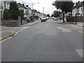
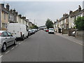
3
Gillingham Road towards Livingstone Circus, Gillingham
Road leads from traffic light junction with Duncan Road and Nelson Road to Livingstone Circus, a roundabout at the end of Barnsole Road.
Image: © David Anstiss
Taken: 8 Jul 2009
0.04 miles
5
Primrose Cottage, Gillingham
On Franklin Road. One of the smallest cottages in Gillingham.
Image: © David Anstiss
Taken: 24 Jul 2009
0.05 miles
6
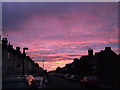
Pink Sunset on Franklin Road
Spectacular display in the evening.
See also Image
Image: © David Anstiss
Taken: 18 Aug 2011
0.06 miles
7
Livingstone Circus, Gillingham
Gillingham Road is to the left, and Ingram Road is to the right. Photo taken from Barnsole Road.
Image: © Danny P Robinson
Taken: 15 Jul 2008
0.06 miles
8
Road junction on Napier Road, Gillingham
Napier Road leads slightly uphill from Canterbury Road to Nelson Road. Coulman Street on left leads to Barnsole Road.
Image: © David Anstiss
Taken: 16 Jul 2009
0.07 miles
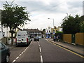
9
Beresord Road, Gillingham
This road leads from Gillingham Road up to Napier County Primary School (seen in the distance) and then left to Napier Road.
Image: © David Anstiss
Taken: 16 Jul 2009
0.07 miles
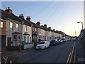
10
Franklin Road, Gillingham
Road leading from Gillingham Road to Duncan Road. Aldi Supermarket at end of the road.
Image: © David Anstiss
Taken: 8 Jul 2009
0.08 miles