IMAGES TAKEN NEAR TO
Lower Rainham Road, GILLINGHAM, ME7 2XT
Introduction
This page details the photographs taken nearby to Lower Rainham Road, ME7 2XT by members of the Geograph project.
The Geograph project started in 2005 with the aim of publishing, organising and preserving representative images for every square kilometre of Great Britain, Ireland and the Isle of Man.

There are currently over 7.5m images from over14,400 individuals and you can help contribute to the project by visiting https://www.geograph.org.uk
Image Map
Images are licensed for reuse under creativecommons.org/licenses/by-sa/2.0
Notes
- Clicking on the map will re-center to the selected point.
- The higher the marker number, the further away the image location is from the centre of the postcode.
Image Listing (44 Images Found)
Images are licensed for reuse under creativecommons.org/licenses/by-sa/2.0
Image
Details
Distance
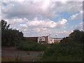
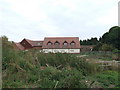
1

Derelict equestrian centre near the Copperhouse Marshes
Image: © N Chadwick
Taken: 5 Apr 2009
0.07 miles
3
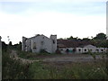
Matthews Riding School, Grange
Apparently closed since the 1980s after being open less than a decade.
Image: © Chris Whippet
Taken: 5 Sep 2010
0.08 miles
4
Matthews Riding School, Grange
Opened by former wrestler Tony Rocco and named after his son who had died, this equestrian centre lasted less than a decade before closing in the 1980s. There were ambitious plans for the centre which were scuppered after the council refused permission for the building of better access roads. A smaller centre was later opened in nearby Capstone.
Image: © Chris Whippet
Taken: 5 Sep 2010
0.08 miles
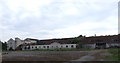
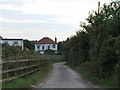
6
Empty Building, Grange
This was built as a hotel I believe next door to Matthew's Riding School and Equestrian Centre.
Image: © Chris Whippet
Taken: 5 Sep 2010
0.11 miles
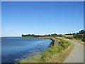
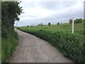
9
Riverside Country Park near Gillingham
This path through the Riverside Country Park forms part of the Saxon Shore Way, and also National Cycle Network route 1.
Image: © Malc McDonald
Taken: 7 Sep 2013
0.12 miles
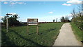
10
Derelict building, part of Walnut Tree Farm
Situated by Copperhouse Marshes, the site was excavated by Canterbury Archaeological Trust earlier in the year prior to a proposed extension to the existing main building. I believe this building is the disused equestrian centre.The footpath in the foreground is the Saxon Shore Way west of the Riverside Country Park.
Image: © pam fray
Taken: 22 Nov 2009
0.12 miles