IMAGES TAKEN NEAR TO
Eastcourt Lane, GILLINGHAM, ME7 2UR
Introduction
This page details the photographs taken nearby to Eastcourt Lane, ME7 2UR by members of the Geograph project.
The Geograph project started in 2005 with the aim of publishing, organising and preserving representative images for every square kilometre of Great Britain, Ireland and the Isle of Man.

There are currently over 7.5m images from over14,400 individuals and you can help contribute to the project by visiting https://www.geograph.org.uk
Image Map
Images are licensed for reuse under creativecommons.org/licenses/by-sa/2.0
Notes
- Clicking on the map will re-center to the selected point.
- The higher the marker number, the further away the image location is from the centre of the postcode.
Image Listing (19 Images Found)
Images are licensed for reuse under creativecommons.org/licenses/by-sa/2.0
Image
Details
Distance
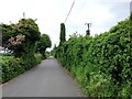
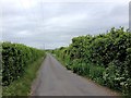
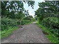
3
Bridleway to Lower Rainham Road
This track leads from the woodland of Riverside Country Park towards the B2004.
It is often used by dog walkers, (hence red dog poo bin) as there is a very small carpark beside the road. Which is open when the official Country Park carparks are closed at dusk.
Image: © David Anstiss
Taken: 7 Aug 2021
0.17 miles
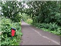
6
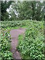
Permissive path crossing Bridleway
A permissive path leads through Riverside Country Park through a former orchard, it crosses over a bridleway that leads left towards Lower Rainham Road and right to a circular route through the orchard.
Image: © David Anstiss
Taken: 7 Aug 2021
0.19 miles
9
Bridleway into Riverside Country Park
This track leads from Lower Rainham Road, through a former orchard and farmland beside the River Medway, it then completes a twists through the park and back out to the track. It crosses permissive footpaths and other bridleway trails (seen on the left) that also loop in the park.
Image: © David Anstiss
Taken: 7 Aug 2021
0.19 miles