IMAGES TAKEN NEAR TO
King Edward Road, GILLINGHAM, ME7 2RE
Introduction
This page details the photographs taken nearby to King Edward Road, ME7 2RE by members of the Geograph project.
The Geograph project started in 2005 with the aim of publishing, organising and preserving representative images for every square kilometre of Great Britain, Ireland and the Isle of Man.

There are currently over 7.5m images from over14,400 individuals and you can help contribute to the project by visiting https://www.geograph.org.uk
Image Map
Images are licensed for reuse under creativecommons.org/licenses/by-sa/2.0
Notes
- Clicking on the map will re-center to the selected point.
- The higher the marker number, the further away the image location is from the centre of the postcode.
Image Listing (109 Images Found)
Images are licensed for reuse under creativecommons.org/licenses/by-sa/2.0
Image
Details
Distance
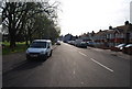
1
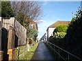
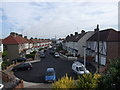
Footpath to Grange Road
A path leads up from Castlemaine Avenue. Towards a corner shop on Grange Road and St Mary's Cemetery open-space area.
Image: © David Anstiss
Taken: 25 Dec 2013
0.07 miles
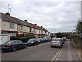
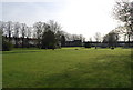
4
Cemetery / Playing Fields of St Mary's Church
St Mary's Church is straight along the footpath and up the slight hill.
Image: © David Anstiss
Taken: 16 Oct 2008
0.08 miles
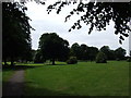
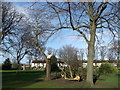
7
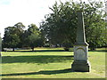
John Smith Memorial, St Mary's Cemetery
This cemetery is also used as a parkland beside St Mary's Church.
This Victorian memorial is dedicated to a former police chief.
Image: © David Anstiss
Taken: 27 Sep 2012
0.09 miles
8
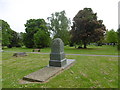
Grange Road Cemetery
It is believed that as early as the 7th century a village was established on this site. There would have been a church of wooden construction but the present church is all that marks the site. In the 12th century a palace for the Archbishops of Canterbury was built here covering over 20 acres but this was suppressed at the Reformation in 1537 and only the church remained. The church is Perpendicular from the outside but there are arches in the interior dating from about 1200. The church was restored in the 1860s.
The churchyard is now combined with Grange Road Cemetery. The churchyard of St. Mary Magdalene closed on 1st April 1859. Two acres of the new Grange Road Cemetery were consecrated on 25th June 1859. It began to fill up rapidly and another seven acres were purchased and the new section was consecrated on 23rd November 1867. At the turn of the 20th century, the cemetery was almost full and a new cemetery was needed which was established at Woodlands Road. Grange Road Cemetery was not closed until 1971.
Most of the gravestones of Grange Road Cemetery were controversially cleared in 1973 so that it is now more like a park with a few monuments scattered about. See http://www.kentarchaeology.org.uk/Research/Libr/MIs/GILGR/01.htm for more information.
Image: © Marathon
Taken: 29 May 2016
0.10 miles
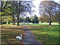
10
Storm damage in St Mary's Cemetery
Several old trees have suffered due to the recent severe storms.
In the background are houses on Layfield Avenue.
Image: © David Anstiss
Taken: 25 Dec 2013
0.10 miles