IMAGES TAKEN NEAR TO
Canadian Avenue, GILLINGHAM, ME7 2DP
Introduction
This page details the photographs taken nearby to Canadian Avenue, ME7 2DP by members of the Geograph project.
The Geograph project started in 2005 with the aim of publishing, organising and preserving representative images for every square kilometre of Great Britain, Ireland and the Isle of Man.

There are currently over 7.5m images from over14,400 individuals and you can help contribute to the project by visiting https://www.geograph.org.uk
Image Map
Images are licensed for reuse under creativecommons.org/licenses/by-sa/2.0
Notes
- Clicking on the map will re-center to the selected point.
- The higher the marker number, the further away the image location is from the centre of the postcode.
Image Listing (64 Images Found)
Images are licensed for reuse under creativecommons.org/licenses/by-sa/2.0
Image
Details
Distance
1
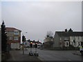
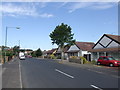
Crossroads on Woodlands Road
Woodlands Road leads left towards the A2 Sovereign Boulevard, or right towards the A289 Danes Hill. Cornwallis Road from Twydall, becomes Canadian Avenue, leading straight on towards Gillingham.
Woodlands Stores (as seen in Image), has been converted into flats and shop. But since the new build last year, the shop has never opened.
Note, the crossroads signals is undergoing temporary maintenance. Why two lights per road is necessary ?????
Image: © David Anstiss
Taken: 20 Jan 2011
0.02 miles
2
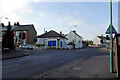
A Corner Shop, Gillingham
Woodlands Stores appeared to be permanently closed, but it may have just been well barricaded when shut on a Sunday morning. It was certainly scruffy.
Image: © Robin Webster
Taken: 4 Feb 2007
0.02 miles
3
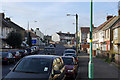
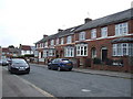
Cornwallis Avenue
Looking towards the junction with Woodlands Road.
Image: © Robin Webster
Taken: 4 Feb 2007
0.03 miles
4
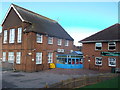
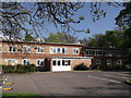
Woodlands Primary School
On Woodlands Road.
It was at one time, Gillingham Community College.
Image: © David Anstiss
Taken: 3 Nov 2013
0.09 miles
5
Woodland Youth Centre, Gillingham
On Woodlands Road.
Image: © David Anstiss
Taken: 1 May 2012
0.12 miles
8
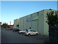
Woodlands School Community Sports and Arts Centre
As seen from the access road from Woodlands Road.
This centre is behind the primary school on the road.
Image: © David Anstiss
Taken: 3 Nov 2013
0.13 miles
9
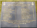
Chatham Marine Cadet's Plaque, Woodlands Road
This memorial plaque is in front of the graves in memory of 25 Royal Marine Cadets who lost their life in a bus crash of 4th December 1951. The young cadets (aged between 9 and 13) were marching along Dock road in Chatham in the fog when a bus ploughed into the cadets killing most of the troop.
See also Image
Image: © David Anstiss
Taken: 9 Feb 2013
0.13 miles
10
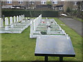
Naval Cadets Memorial and Graves, Woodlands Road Cemetery
This memorial plaque and graves are in memory of 25 Royal Marine Cadets who lost their life in a bus crash of 4th December 1951. The young cadets (aged between 9 and 13) were marching along Dock road in Chatham in the fog when a bus ploughed into the cadets killing most of the troop.
Image: © David Anstiss
Taken: 9 Feb 2013
0.13 miles