IMAGES TAKEN NEAR TO
The Vineries, GILLINGHAM, ME7 2AD
Introduction
This page details the photographs taken nearby to The Vineries, ME7 2AD by members of the Geograph project.
The Geograph project started in 2005 with the aim of publishing, organising and preserving representative images for every square kilometre of Great Britain, Ireland and the Isle of Man.

There are currently over 7.5m images from over14,400 individuals and you can help contribute to the project by visiting https://www.geograph.org.uk
Image Map
Images are licensed for reuse under creativecommons.org/licenses/by-sa/2.0
Notes
- Clicking on the map will re-center to the selected point.
- The higher the marker number, the further away the image location is from the centre of the postcode.
Image Listing (142 Images Found)
Images are licensed for reuse under creativecommons.org/licenses/by-sa/2.0
Image
Details
Distance
2
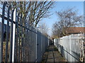
Footpath to Ingram Road, Gillingham
This path leads from Woodlands Road towards Ingram Road. It follows the railway line (on the left). On the right is part of the Vineries Housing estate.
Image: © David Anstiss
Taken: 19 Feb 2013
0.05 miles
3
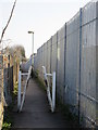
Railway footpath near Maple Avenue
It leads beside the railway to Woodlands Road.
See also Image
Image: © David Anstiss
Taken: 25 Dec 2014
0.06 miles