IMAGES TAKEN NEAR TO
Baden Road, GILLINGHAM, ME7 1RE
Introduction
This page details the photographs taken nearby to Baden Road, ME7 1RE by members of the Geograph project.
The Geograph project started in 2005 with the aim of publishing, organising and preserving representative images for every square kilometre of Great Britain, Ireland and the Isle of Man.

There are currently over 7.5m images from over14,400 individuals and you can help contribute to the project by visiting https://www.geograph.org.uk
Image Map
Images are licensed for reuse under creativecommons.org/licenses/by-sa/2.0
Notes
- Clicking on the map will re-center to the selected point.
- The higher the marker number, the further away the image location is from the centre of the postcode.
Image Listing (168 Images Found)
Images are licensed for reuse under creativecommons.org/licenses/by-sa/2.0
Image
Details
Distance
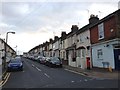
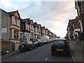
3
Corner of Milner Road and Pier Road, Gillingham
Image: © Chris Whippet
Taken: 12 Jun 2009
0.04 miles
4
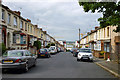
Milner Road, Gillingham
Dropping down to Pier Road, with the modern Liberty Quays buildings on the other side.
Image: © Robin Webster
Taken: 23 Jun 2012
0.05 miles
6
Pier Road, Gillingham
A view east on Pier Road, Gillingham, looking towards some newly-built apartments.
Image: © Malc McDonald
Taken: 7 Sep 2013
0.07 miles
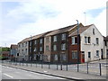
8
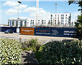
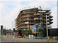
Erection of a building, Pier Road
Planning permission has been approved, with conditions, by Medway Council under application number MC/09/0698 for “approval of reserved matters (external appearance, design and landscaping) of planning permission MC2004/1214 for Block M (part of Phase 1 development under permission MC2006/1283) now to provide 43 shared ownership flats and 60 care assisted residential flats with ancillary facilities, landscaping and parking. (amended total development for Phase 1 is 3, 54 residential units, 4 live/work units, 709 square metres A3 (restaurant) use, 165 square metres A1 (retail) use, Harbourmasters and public riverside walk with associated landscaping and car parking)”.
Image: © John Baker
Taken: 9 May 2018
0.08 miles
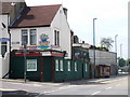
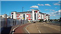
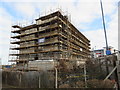
9
Construction beside Pier Road
This building, part of the Liberty Quays development will be a Premier Inn motel.
Image: © David Anstiss
Taken: 25 Jan 2015
0.08 miles
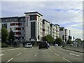
10
Premier Inn under construction
This large motel building beside Pier Road, is part of the Liberty Pier development.
In the background is Formidable House, part of the University of Kent's student accommodation buildings.
Image: © David Anstiss
Taken: 25 Jan 2015
0.08 miles