IMAGES TAKEN NEAR TO
Mill Road, GILLINGHAM, ME7 1HZ
Introduction
This page details the photographs taken nearby to Mill Road, ME7 1HZ by members of the Geograph project.
The Geograph project started in 2005 with the aim of publishing, organising and preserving representative images for every square kilometre of Great Britain, Ireland and the Isle of Man.

There are currently over 7.5m images from over14,400 individuals and you can help contribute to the project by visiting https://www.geograph.org.uk
Image Map (Loading...)


Getting Data...Please wait
Leaflet Map data © OpenStreetMap
Images are licensed for reuse under creativecommons.org/licenses/by-sa/2.0
Notes
- Clicking on the map will re-center to the selected point.
- The higher the marker number, the further away the image location is from the centre of the postcode.
Image Listing (375 Images Found)
Images are licensed for reuse under creativecommons.org/licenses/by-sa/2.0
Image
Details
Distance
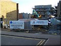
1
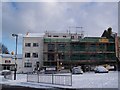
Construction Site on Mill Road
Site on Mill Road, close to the junction with Brompton Road. Nearly completed.
Compare with Image
Image: © David Anstiss
Taken: 7 Jan 2010
0.02 miles
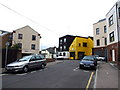
3
Development on Mill Road, Gillingham
On empty site for many years, not square site so developers will have to be creative.
Image: © David Anstiss
Taken: 29 Oct 2008
0.02 miles
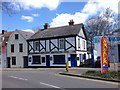
4
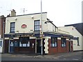
The Monarch Public House, Gillingham
On junction of Fox Street and Arden Street.
Image: © David Anstiss
Taken: 3 Nov 2008
0.02 miles
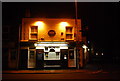
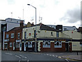
7
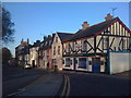
Marquis of Lorne, Mill Road, Gillingham
Image: © Chris Whippet
Taken: 10 Dec 2009
0.03 miles
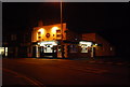
8
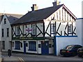
The Marquis of Lorne Public House
On Mill Road.
Image: © David Anstiss
Taken: 29 Oct 2008
0.03 miles