IMAGES TAKEN NEAR TO
Ocean Drive, GILLINGHAM, ME7 1FT
Introduction
This page details the photographs taken nearby to Ocean Drive, ME7 1FT by members of the Geograph project.
The Geograph project started in 2005 with the aim of publishing, organising and preserving representative images for every square kilometre of Great Britain, Ireland and the Isle of Man.

There are currently over 7.5m images from over14,400 individuals and you can help contribute to the project by visiting https://www.geograph.org.uk
Image Map
Images are licensed for reuse under creativecommons.org/licenses/by-sa/2.0
Notes
- Clicking on the map will re-center to the selected point.
- The higher the marker number, the further away the image location is from the centre of the postcode.
Image Listing (153 Images Found)
Images are licensed for reuse under creativecommons.org/licenses/by-sa/2.0
Image
Details
Distance
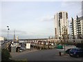
1

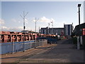
The Boathouse, Victory Pier
This large block of apartments is one of the early phases of the Victory Pier Development being built by the Berkeley Group.
On the ground floor, on the left is a fitness studio and on the right, tenants are being sort for a bar/diner facility.
In the foreground is Image
See http://www.lv21.co.uk/lv21-blog/
Image: © David Anstiss
Taken: 19 Mar 2012
0.01 miles
3
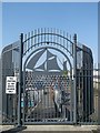
Gate to Gillingham Pier
Has a cut metal image of a Thames wharf barge.
Image: © David Anstiss
Taken: 6 Jun 2013
0.03 miles
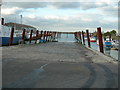
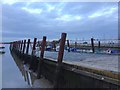
5
Gillingham Pier
This dock is at the end of Pier Approach Road, on the River Medway.
The large building overlooking the pier is part of the Victory Pier development. This is a block of new apartments with a (public accessible) gym on the ground floor.
Image: © David Anstiss
Taken: 14 Sep 2011
0.03 miles
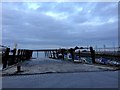
6
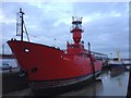
Lightship at Gillingham Pier
Currently used as a floating Arts and performance space. http://www.lv21.co.uk/
Image: © Chris Whippet
Taken: 26 Oct 2014
0.03 miles
8

Lightship LV 21 at Gillingham pier: the ship's bridge and lantern
Image: © Stefan Czapski
Taken: 25 Jul 2012
0.04 miles
9
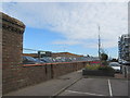
Pier Approach Road Wall
This wall was a post-planning hold-up of the new Asda store being built. Liberty Piers buildings (this side) of the wall wanted to keep the wall, so residents did not look at a petrol station. But Asda wanted to remove the wall. A compromise seems to have been found.
Image: © David Anstiss
Taken: 28 Aug 2015
0.04 miles