IMAGES TAKEN NEAR TO
Watts Close, SNODLAND, ME6 5TA
Introduction
This page details the photographs taken nearby to Watts Close, ME6 5TA by members of the Geograph project.
The Geograph project started in 2005 with the aim of publishing, organising and preserving representative images for every square kilometre of Great Britain, Ireland and the Isle of Man.

There are currently over 7.5m images from over14,400 individuals and you can help contribute to the project by visiting https://www.geograph.org.uk
Image Map
Images are licensed for reuse under creativecommons.org/licenses/by-sa/2.0
Notes
- Clicking on the map will re-center to the selected point.
- The higher the marker number, the further away the image location is from the centre of the postcode.
Image Listing (126 Images Found)
Images are licensed for reuse under creativecommons.org/licenses/by-sa/2.0
Image
Details
Distance
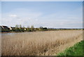
1
Looking across the River Medway to Snodland
Image: © N Chadwick
Taken: 15 Apr 2010
0.03 miles

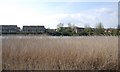
6
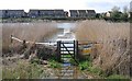
Drainage channel enters the River Medway
The photo was taken at high tide.
Image: © N Chadwick
Taken: 15 Apr 2010
0.05 miles
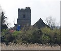
8
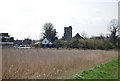
Looking across reed beds to Snodland Church
Image: © N Chadwick
Taken: 15 Apr 2010
0.06 miles
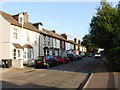
9
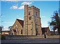
All Saints Church, Snodland
This church stands at the end of Mill Street opposite the (relatively modern) paper mill. A railway and recent bypass road has now almost cut off this part of the town from the historical centre of the community.
Image: © Richard Dorrell
Taken: 12 Mar 2008
0.06 miles