IMAGES TAKEN NEAR TO
Pollyfield Close, SNODLAND, ME6 5GQ
Introduction
This page details the photographs taken nearby to Pollyfield Close, ME6 5GQ by members of the Geograph project.
The Geograph project started in 2005 with the aim of publishing, organising and preserving representative images for every square kilometre of Great Britain, Ireland and the Isle of Man.

There are currently over 7.5m images from over14,400 individuals and you can help contribute to the project by visiting https://www.geograph.org.uk
Image Map
Images are licensed for reuse under creativecommons.org/licenses/by-sa/2.0
Notes
- Clicking on the map will re-center to the selected point.
- The higher the marker number, the further away the image location is from the centre of the postcode.
Image Listing (43 Images Found)
Images are licensed for reuse under creativecommons.org/licenses/by-sa/2.0
Image
Details
Distance

6
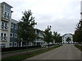
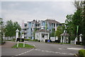
Manley Boulevard, Holborough Lakes near Snodland
Image: © Chris Whippet
Taken: 31 Aug 2009
0.10 miles
9
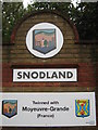
Close-up of Snodland Village Sign
This is a closeup of Image
The sign shows, the local village features; on the left a cement factory (reference to the Lafarge Factory nearby), the clock tower (see http://www.geograph.org.uk/photo/226180), All Saints Church (see http://www.geograph.org.uk/photo/665722). The river Medway flows along the bottom, with a tree growing out of it.
Below the sign is a sign of the twinship with a French Town.
See http://en.wikipedia.org/wiki/Moyeuvre-Grande for details on the town.
Image: © David Anstiss
Taken: 5 Oct 2010
0.12 miles
10
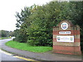
Snodland Village Sign
On Holborough Road, near the A228 Halling bypass (on the left).
This town/village has two of these brick built signs, either end of the main road through the village. The other is near the Malling Road roundabout, at the other end of the A228 bypass (now called the Snodland bypass!).
Image: © David Anstiss
Taken: 5 Oct 2010
0.12 miles