IMAGES TAKEN NEAR TO
Church Field, SNODLAND, ME6 5AR
Introduction
This page details the photographs taken nearby to Church Field, ME6 5AR by members of the Geograph project.
The Geograph project started in 2005 with the aim of publishing, organising and preserving representative images for every square kilometre of Great Britain, Ireland and the Isle of Man.

There are currently over 7.5m images from over14,400 individuals and you can help contribute to the project by visiting https://www.geograph.org.uk
Image Map
Images are licensed for reuse under creativecommons.org/licenses/by-sa/2.0
Notes
- Clicking on the map will re-center to the selected point.
- The higher the marker number, the further away the image location is from the centre of the postcode.
Image Listing (140 Images Found)
Images are licensed for reuse under creativecommons.org/licenses/by-sa/2.0
Image
Details
Distance
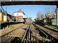
3
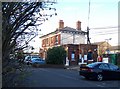
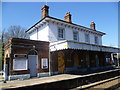
Snodland station
This attractive building also usefully houses an Indian take-away...
Image: © Richard Dorrell
Taken: 12 Mar 2008
0.02 miles
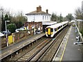
5
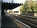
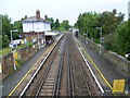
Snodland railway station, Kent
Opened in 1856 by the South Eastern Railway on the line from Paddock Wood to Strood.
View north from the level crossing towards Halling and Strood.
Image: © Nigel Thompson
Taken: 11 Jan 2014
0.04 miles
7
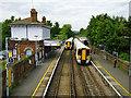
Trains pass at Snodland
The 15:14 departure to Strood pulls away on the left, while the 15:15 departure to Tonbridge pulls up on the right. The three-car units are 375 303 and 309 respectively. The station building is boarded up to the railway side, but houses a Bangladeshi takeaway to the street side.
Image: © Robin Webster
Taken: 13 Jun 2012
0.05 miles
8
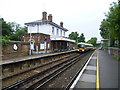
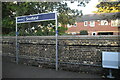
Snodland station
The Medway Valley Line was built in two stages by the South Eastern Railway. The first stage opened in 1844 was from Paddock Wood following the Medway Valley to Maidstone. In 1856 the line was extended down the Medway Valley to the North Kent Line at Strood (which had opened in 1847). Snodland station opened like the rest of the line on 18th June 1856. The original station building on the northbound platform was closed in the 1990s and became an Indian restaurant. This view of the station sees a northbound train setting off for Strood.
Image: © Marathon
Taken: 1 Aug 2012
0.05 miles
9
Snodland station from the footbridge
The Medway Valley Line was built in two stages by the South Eastern Railway. The first stage opened in 1844 was from Paddock Wood following the Medway Valley to Maidstone. In 1856 the line was extended down the Medway Valley to the North Kent Line at Strood (which had opened in 1847). Snodland station opened like the rest of the line on 18th June 1856. The original station building on the northbound platform was closed in the 1990s and became an Indian restaurant. This view of the station from the footbridge sees a northbound train on its way to Strood.
Image: © Marathon
Taken: 1 Aug 2012
0.05 miles
10
The old station building at Snodland
The Medway Valley Line was built in two stages by the South Eastern Railway. The first stage opened in 1844 was from Paddock Wood following the Medway Valley to Maidstone. In 1856 the line was extended down the Medway Valley to the North Kent Line at Strood (which had opened in 1847). Snodland station opened like the rest of the line on 18th June 1856. The original station building on the northbound platform was closed in the 1990s and became an Indian restaurant. As can be seen here some colourful murals have been added.
Image: © Marathon
Taken: 23 Apr 2013
0.05 miles