IMAGES TAKEN NEAR TO
High Street, SNODLAND, ME6 5AL
Introduction
This page details the photographs taken nearby to High Street, ME6 5AL by members of the Geograph project.
The Geograph project started in 2005 with the aim of publishing, organising and preserving representative images for every square kilometre of Great Britain, Ireland and the Isle of Man.

There are currently over 7.5m images from over14,400 individuals and you can help contribute to the project by visiting https://www.geograph.org.uk
Image Map
Images are licensed for reuse under creativecommons.org/licenses/by-sa/2.0
Notes
- Clicking on the map will re-center to the selected point.
- The higher the marker number, the further away the image location is from the centre of the postcode.
Image Listing (167 Images Found)
Images are licensed for reuse under creativecommons.org/licenses/by-sa/2.0
Image
Details
Distance
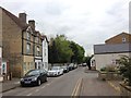
2
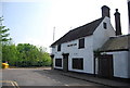
Red Lion Public House, High Street, Snodland, Kent
Compulsory purchased when the adjacent bypass was constructed. However it wasn't necessary to demolish it and it has been left derelict since.
As featured on "Homes Under The Hammer".
Image: © Oast House Archive
Taken: 21 May 2009
0.01 miles
4
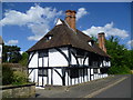
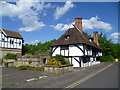
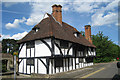
Mulberry Cottage, Snodland
Looking like it belongs in a rural Kent village, Mulberry Cottage is a Wealden half-timbered house. It is actually at the end of the High Street in Snodland with the busy A228 just beyond the trees on the right.
Image: © Marathon
Taken: 6 May 2014
0.01 miles
5
Mulberry Cottage, Snodland
Looking like it belongs in a rural Kent village, Mulberry Cottage is a Wealden half-timbered house. It is actually at the end of the High Street in Snodland with the busy A228 just behind the trees beyond.
Image: © Marathon
Taken: 6 May 2014
0.01 miles
6
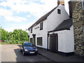
Mulberry Cottages, High Street, Snodland, Kent
Grade II listed.
Image: © Oast House Archive
Taken: 21 May 2009
0.01 miles
7
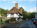
Mulberry Cottage, Snodland
Mulberry Cottage, in the town of Snodland, dates from the mid-15th Century. It is a Grade II* Listed Building.
For more information, see the Historic England website: https://historicengland.org.uk/listing/the-list/list-entry/1070485
Image: © Malc McDonald
Taken: 3 Oct 2021
0.01 miles
8
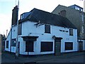
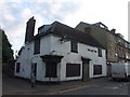
Red Lion couchant
It looks like the Red Lion will roar no more. This derelict pub stands opposite the ancient Mulberry Cottage Image in Snodland High Street. This spot was the original centre of Snodland. But time moves on... A bypass was built, the business centre of the town moved half a mile west, and the Red Lion died.
Image: © Richard Dorrell
Taken: 12 Mar 2008
0.01 miles
10
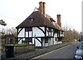
Mulberry Cottage, Snodland
Named for the mulberry tree that grew in the garden, this 15th century Wealden Hall House in the High Street was once at the centre of Snodland, where the market cross stood outside The Red Lion inn opposite. In the 1920s, the cottage was stripped to its skeleton and rebuilt, using original materials wherever possible.
Image: © Richard Dorrell
Taken: 22 Jan 2008
0.02 miles