IMAGES TAKEN NEAR TO
Warren Road, CHATHAM, ME5 9RD
Introduction
This page details the photographs taken nearby to Warren Road, ME5 9RD by members of the Geograph project.
The Geograph project started in 2005 with the aim of publishing, organising and preserving representative images for every square kilometre of Great Britain, Ireland and the Isle of Man.

There are currently over 7.5m images from over14,400 individuals and you can help contribute to the project by visiting https://www.geograph.org.uk
Image Map
Images are licensed for reuse under creativecommons.org/licenses/by-sa/2.0
Notes
- Clicking on the map will re-center to the selected point.
- The higher the marker number, the further away the image location is from the centre of the postcode.
Image Listing (41 Images Found)
Images are licensed for reuse under creativecommons.org/licenses/by-sa/2.0
Image
Details
Distance
1
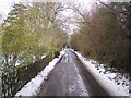
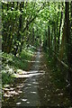
Warren Road
This road leads from Lower Warren Road towards Blue Bell Hill. It is the route of a ancient Roman Road from Maidstone to Chatham/Rochester.
Image: © David Anstiss
Taken: 24 Dec 2009
0.07 miles
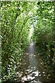
3
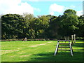
Podkin Meadow, Blue Bell Hill
This small green meadow on Mill Lane, has a series of wooden keepfit activities obstabcles around it.
Image: © David Anstiss
Taken: 14 Oct 2012
0.11 miles
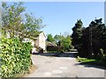
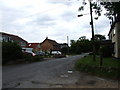
4
Podkin Meadow
Near Mill Lane. Kissing Gate entry on the right, on a footpath to Robin Hill Lane. Also another path heads right past a farm towards Podkin and Frith Woods.
Image: © David Anstiss
Taken: 24 Dec 2009
0.11 miles
8
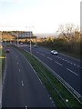
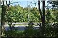
The A229 towards Maidstone
From Blue Bell Hill, Common Road.
Image: © David Anstiss
Taken: 28 Oct 2008
0.13 miles
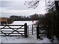
10
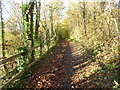
North Downs Way approaching Blue Bell Hill
The A229, here also known as Blue Bell Hill, is to the right but out of sight.
Image: © Marathon
Taken: 10 Nov 2013
0.14 miles