IMAGES TAKEN NEAR TO
Robin Hood Lane, CHATHAM, ME5 9NS
Introduction
This page details the photographs taken nearby to Robin Hood Lane, ME5 9NS by members of the Geograph project.
The Geograph project started in 2005 with the aim of publishing, organising and preserving representative images for every square kilometre of Great Britain, Ireland and the Isle of Man.

There are currently over 7.5m images from over14,400 individuals and you can help contribute to the project by visiting https://www.geograph.org.uk
Image Map
Images are licensed for reuse under creativecommons.org/licenses/by-sa/2.0
Notes
- Clicking on the map will re-center to the selected point.
- The higher the marker number, the further away the image location is from the centre of the postcode.
Image Listing (56 Images Found)
Images are licensed for reuse under creativecommons.org/licenses/by-sa/2.0
Image
Details
Distance
8
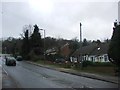
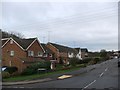
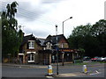
Robin Hood Lane, Walderslade
With Sherwood Drive on the left and Walderslade By-pass on the right.
Image: © Chris Whippet
Taken: 18 Jun 2009
0.06 miles
10
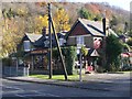
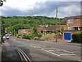
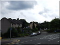
Sherwood Oak Public House, Walderslade
On junction of Robin Hood lane and Boxley Road.
Image: © David Anstiss
Taken: 11 Nov 2008
0.07 miles