IMAGES TAKEN NEAR TO
Mead Green, CHATHAM, ME5 8PB
Introduction
This page details the photographs taken nearby to Mead Green, ME5 8PB by members of the Geograph project.
The Geograph project started in 2005 with the aim of publishing, organising and preserving representative images for every square kilometre of Great Britain, Ireland and the Isle of Man.

There are currently over 7.5m images from over14,400 individuals and you can help contribute to the project by visiting https://www.geograph.org.uk
Image Map
Images are licensed for reuse under creativecommons.org/licenses/by-sa/2.0
Notes
- Clicking on the map will re-center to the selected point.
- The higher the marker number, the further away the image location is from the centre of the postcode.
Image Listing (28 Images Found)
Images are licensed for reuse under creativecommons.org/licenses/by-sa/2.0
Image
Details
Distance
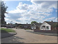
2
Hatton Road leading to Ballen's Rough
From Ballens Road. Also leads to small allotments on right and footpath to underpass under North Danes Way.
Image: © David Anstiss
Taken: 11 Nov 2008
0.08 miles
4
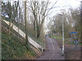
Bridleway and cyclepath junction near Ballen's Rough
A cycleway leads beside North Dane Way (road on the embankment on the left),towards Albermarle Road. A bridleway heads under the underpass (on the left) under the road towards Hook Wood and onwards to Sharsted Farm on Shawstead Road. It also heads right towards the small woodland beside Ballens Road.
Image: © David Anstiss
Taken: 24 Feb 2011
0.11 miles
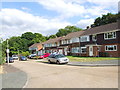
5

Ballen's Rough
A fragment of woodland west of North Dane Way.
Image: © Robin Webster
Taken: 25 Jun 2012
0.11 miles
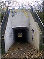
8
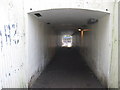
Underpass under North Danes Way
This tunnel (part of a bridleway) goes under North Dane Way, from Ballen's Rough and a cyclepath beside North Dane Way.
It leads towards Hook Wood and Sharsted Farm on Shawstead Road.
Compare with Image, looking the other way!
Image: © David Anstiss
Taken: 24 Feb 2011
0.13 miles
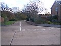
10
Underpass to Ballen's Rough
Goes under North Dane Way, from Hook Wood.
Cyclepath at end of tunnel, goes right to Capstone Country Park, or left to Playing Fields / Kestrel Shopping Centre.
Image: © David Anstiss
Taken: 11 Nov 2008
0.13 miles