IMAGES TAKEN NEAR TO
Princes Avenue, CHATHAM, ME5 8BA
Introduction
This page details the photographs taken nearby to Princes Avenue, ME5 8BA by members of the Geograph project.
The Geograph project started in 2005 with the aim of publishing, organising and preserving representative images for every square kilometre of Great Britain, Ireland and the Isle of Man.

There are currently over 7.5m images from over14,400 individuals and you can help contribute to the project by visiting https://www.geograph.org.uk
Image Map
Images are licensed for reuse under creativecommons.org/licenses/by-sa/2.0
Notes
- Clicking on the map will re-center to the selected point.
- The higher the marker number, the further away the image location is from the centre of the postcode.
Image Listing (46 Images Found)
Images are licensed for reuse under creativecommons.org/licenses/by-sa/2.0
Image
Details
Distance
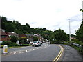
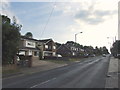
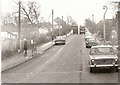
5
Roundabout on Walderslade Road
Right goes on Walderslade Road, uphill to Weeds Wood and A230.
Left goes on Walderslade Village By-pass, downhill to M2/A229 junction.
Viewer on Princess Avenue, downhill to Gillingham.
Normal extremely busy junction.
Image: © David Anstiss
Taken: 11 Nov 2008
0.07 miles
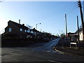
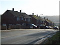
7
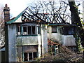
Burnt out house on Walderslade Road, Walderslade
Image: © Chris Whippet
Taken: 17 Dec 2008
0.11 miles