IMAGES TAKEN NEAR TO
Watchmans Terrace, Beacon Road, CHATHAM, ME5 7TS
Introduction
This page details the photographs taken nearby to Watchmans Terrace, Beacon Road, ME5 7TS by members of the Geograph project.
The Geograph project started in 2005 with the aim of publishing, organising and preserving representative images for every square kilometre of Great Britain, Ireland and the Isle of Man.

There are currently over 7.5m images from over14,400 individuals and you can help contribute to the project by visiting https://www.geograph.org.uk
Image Map
Images are licensed for reuse under creativecommons.org/licenses/by-sa/2.0
Notes
- Clicking on the map will re-center to the selected point.
- The higher the marker number, the further away the image location is from the centre of the postcode.
Image Listing (102 Images Found)
Images are licensed for reuse under creativecommons.org/licenses/by-sa/2.0
Image
Details
Distance
2
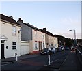
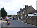
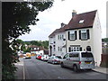
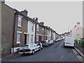
Road junction on Beacon Road, Chatham
Beacon Hill leads to Luton Highs. Beacon Road heads left to Ash Tree Lane.
Image: © David Anstiss
Taken: 26 Aug 2009
0.03 miles
5
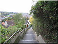
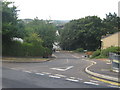
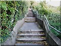
Sugar Loaf Hill
This flight of steps runs from Ash Tree Lane down to Beacon Road. The steps are now overgrown and rather forbidding but at one time afforded pleasant views over the Luton Valley.
Image: © Roland Pilcher
Taken: 14 Oct 2008
0.05 miles
7
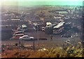
View over Luton Part 1
This picture was taken in February 1979 and shows the view over Luton Village from just above Beacon Road. The man crossing Beacon road has just descended the steps of Sugar Loaf Hill and is about to go down Church Hill. He is wrapped up against the cold which is also testified by the odd patch of snow. The coach yard on the other side of Beacon Road was used by Pilchers Coaches.
Just above the furthest coaches can be seen some buses belonging to the Maidstone & District company. The long sheds beyond the buses are part of the Maidstone & District bus depot but they were originally built to house the trams of the Chatham & District Light Railway Company. To the right of the sheds is a building with two large gable ends. This was built as a power station and it housed the steam engines which provided electricity for the trams. The tram depot was built in the early nineteen hundreds, though the actual tram sheds looked surprisingly modern.
In the background is the chalk grassland known as the Coney Banks.
Image: © Roland Pilcher
Taken: 1 Feb 1979
0.05 miles
10
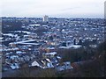
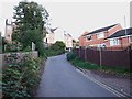
View of the snow covered houses of Luton, Chatham
Seen from near to Ash Tree Lane.
Image: © David Anstiss
Taken: 24 Dec 2009
0.07 miles