IMAGES TAKEN NEAR TO
Penfold Close, CHATHAM, ME5 7RX
Introduction
This page details the photographs taken nearby to Penfold Close, ME5 7RX by members of the Geograph project.
The Geograph project started in 2005 with the aim of publishing, organising and preserving representative images for every square kilometre of Great Britain, Ireland and the Isle of Man.

There are currently over 7.5m images from over14,400 individuals and you can help contribute to the project by visiting https://www.geograph.org.uk
Image Map
Images are licensed for reuse under creativecommons.org/licenses/by-sa/2.0
Notes
- Clicking on the map will re-center to the selected point.
- The higher the marker number, the further away the image location is from the centre of the postcode.
Image Listing (28 Images Found)
Images are licensed for reuse under creativecommons.org/licenses/by-sa/2.0
Image
Details
Distance
6
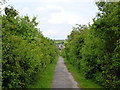
Public footpath from Princes Park
Here it is hemmed in by dense scrub, which as well as blocking what would have been good views to the right, has probably ruined a good bank of downland.
Image: © Robin Webster
Taken: 25 Jun 2012
0.06 miles
7
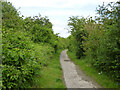
Public footpath RC36, Princes Park
From Swallow Rise to Heron Way.
Image: © Robin Webster
Taken: 25 Jun 2012
0.09 miles