IMAGES TAKEN NEAR TO
Spitfire Close, CHATHAM, ME5 7QP
Introduction
This page details the photographs taken nearby to Spitfire Close, ME5 7QP by members of the Geograph project.
The Geograph project started in 2005 with the aim of publishing, organising and preserving representative images for every square kilometre of Great Britain, Ireland and the Isle of Man.

There are currently over 7.5m images from over14,400 individuals and you can help contribute to the project by visiting https://www.geograph.org.uk
Image Map
Images are licensed for reuse under creativecommons.org/licenses/by-sa/2.0
Notes
- Clicking on the map will re-center to the selected point.
- The higher the marker number, the further away the image location is from the centre of the postcode.
Image Listing (29 Images Found)
Images are licensed for reuse under creativecommons.org/licenses/by-sa/2.0
Image
Details
Distance
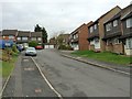
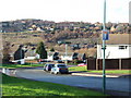
1
Housing on Swift Crescent and roads off
Looking over Redwing Road in the bottom.
Image: © Robin Webster
Taken: 25 Jun 2012
0.02 miles


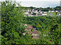
8
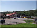
Kingfisher Primary School, Princes Park
School beside Princes Avenue.
Behind is part of Princes Park valley.
Image: © David Anstiss
Taken: 23 Jul 2012
0.15 miles