IMAGES TAKEN NEAR TO
Church Hill, CHATHAM, ME5 7DF
Introduction
This page details the photographs taken nearby to Church Hill, ME5 7DF by members of the Geograph project.
The Geograph project started in 2005 with the aim of publishing, organising and preserving representative images for every square kilometre of Great Britain, Ireland and the Isle of Man.

There are currently over 7.5m images from over14,400 individuals and you can help contribute to the project by visiting https://www.geograph.org.uk
Image Map
Images are licensed for reuse under creativecommons.org/licenses/by-sa/2.0
Notes
- Clicking on the map will re-center to the selected point.
- The higher the marker number, the further away the image location is from the centre of the postcode.
Image Listing (101 Images Found)
Images are licensed for reuse under creativecommons.org/licenses/by-sa/2.0
Image
Details
Distance
4
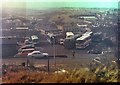
View over Luton Part 1
This picture was taken in February 1979 and shows the view over Luton Village from just above Beacon Road. The man crossing Beacon road has just descended the steps of Sugar Loaf Hill and is about to go down Church Hill. He is wrapped up against the cold which is also testified by the odd patch of snow. The coach yard on the other side of Beacon Road was used by Pilchers Coaches.
Just above the furthest coaches can be seen some buses belonging to the Maidstone & District company. The long sheds beyond the buses are part of the Maidstone & District bus depot but they were originally built to house the trams of the Chatham & District Light Railway Company. To the right of the sheds is a building with two large gable ends. This was built as a power station and it housed the steam engines which provided electricity for the trams. The tram depot was built in the early nineteen hundreds, though the actual tram sheds looked surprisingly modern.
In the background is the chalk grassland known as the Coney Banks.
Image: © Roland Pilcher
Taken: 1 Feb 1979
0.05 miles
6
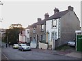
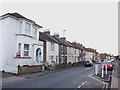
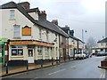
Church Hill, Luton, Chatham
Near Upper Luton Road and Church Terrace.
Image: © Danny P Robinson
Taken: 19 Mar 2008
0.07 miles
7
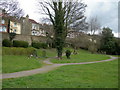
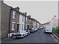
Open Space and Church Terrace, Chatham
Near the junction of Upper Luton Road and Luton Road.
Image: © Danny P Robinson
Taken: 19 Mar 2008
0.07 miles
8
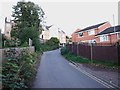
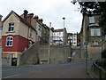
Luton High Street at Luton Road, Chatham
Upper Luton Road is on the right, near Christ Church, Luton. Luton High Street becomes Luton Road at the junction but as there is no break in priority the distinction is irrelevant to through traffic.
Image: © Danny P Robinson
Taken: 19 Mar 2008
0.07 miles
10
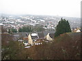
View over Luton Part 2
February 2009, exactly thirty years later, and a great deal has changed, even though there is once again snow on the ground.
Trees and new housing on Beacon Road obscure the original vantage point. In order to get a view of the same scene a higher viewpoint was needed. This involved a scramble through thick scrub and in spite of the effort, the camera is still a bit to the left of its previous position.
Pilchers coach yard has gone and been replaced by the Village View Estate. The trees in Church Terrace are taller and covered in Ivy. The Maidstone & District bus depot has gone and has been replaced by the Tramways Estate. The tram power station is now modern industrial units.
It is mainly housing that provides continuity with the earlier view. The houses with mock tudor gables in Luton High Street are still there, just visible between the thick clumps of ivy, but of course the office block behind them has gone. The industrial buildings in Third Avenue can still be made out though they have changed colour somewhat.
The Coney Banks have survived relatively unscathed.
Image: © Roland Pilcher
Taken: 5 Feb 2009
0.10 miles