IMAGES TAKEN NEAR TO
King George Road, CHATHAM, ME5 0PL
Introduction
This page details the photographs taken nearby to King George Road, ME5 0PL by members of the Geograph project.
The Geograph project started in 2005 with the aim of publishing, organising and preserving representative images for every square kilometre of Great Britain, Ireland and the Isle of Man.

There are currently over 7.5m images from over14,400 individuals and you can help contribute to the project by visiting https://www.geograph.org.uk
Image Map
Images are licensed for reuse under creativecommons.org/licenses/by-sa/2.0
Notes
- Clicking on the map will re-center to the selected point.
- The higher the marker number, the further away the image location is from the centre of the postcode.
Image Listing (51 Images Found)
Images are licensed for reuse under creativecommons.org/licenses/by-sa/2.0
Image
Details
Distance
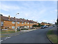
7
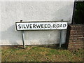
Vintage street nameplate, Silverweed Road, Weedswood
Image: © Chris Whippet
Taken: 16 Jul 2014
0.12 miles
10
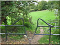
Squeeze Gate near Kemp Close
This 'jump-over' gate is at the end of Kemp Close. It leads from the close into Teddington Valley.
Just behind the shrubs on the left, is an obligitary Asda Shopping Trolley.
Image: © David Anstiss
Taken: 15 Oct 2010
0.13 miles