IMAGES TAKEN NEAR TO
Barnfield, CHATHAM, ME5 0HT
Introduction
This page details the photographs taken nearby to Barnfield, ME5 0HT by members of the Geograph project.
The Geograph project started in 2005 with the aim of publishing, organising and preserving representative images for every square kilometre of Great Britain, Ireland and the Isle of Man.

There are currently over 7.5m images from over14,400 individuals and you can help contribute to the project by visiting https://www.geograph.org.uk
Image Map
Images are licensed for reuse under creativecommons.org/licenses/by-sa/2.0
Notes
- Clicking on the map will re-center to the selected point.
- The higher the marker number, the further away the image location is from the centre of the postcode.
Image Listing (43 Images Found)
Images are licensed for reuse under creativecommons.org/licenses/by-sa/2.0
Image
Details
Distance
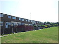
5
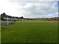
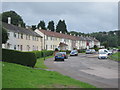
Barnfield, Chatham
Barnfield and Barnfield Recreation Ground. Adjacent to Coney Banks.
Image: © Richard Gadsby
Taken: 7 Jan 2018
0.06 miles
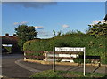
6
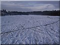
Wayfield Recreation Ground
This snow covered large area, is beside Barnfield on the left and the Coney Banks (the trees and sloped ground) on the right.
Image: © David Anstiss
Taken: 24 Dec 2009
0.07 miles