IMAGES TAKEN NEAR TO
Alfred Close, CHATHAM, ME4 5EE
Introduction
This page details the photographs taken nearby to Alfred Close, ME4 5EE by members of the Geograph project.
The Geograph project started in 2005 with the aim of publishing, organising and preserving representative images for every square kilometre of Great Britain, Ireland and the Isle of Man.

There are currently over 7.5m images from over14,400 individuals and you can help contribute to the project by visiting https://www.geograph.org.uk
Image Map
Images are licensed for reuse under creativecommons.org/licenses/by-sa/2.0
Notes
- Clicking on the map will re-center to the selected point.
- The higher the marker number, the further away the image location is from the centre of the postcode.
Image Listing (89 Images Found)
Images are licensed for reuse under creativecommons.org/licenses/by-sa/2.0
Image
Details
Distance
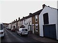
3
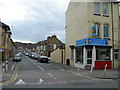
Connaught Road, Chatham
At the junction of Luton Road.
Image: © Danny P Robinson
Taken: 19 Mar 2008
0.07 miles
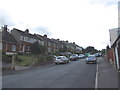
4
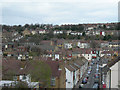
Grove Road, Chatham and view beyond.
Looking along Grove Road, near the junction with Chamberlain Road. Luton Road runs left / right through the centre of the picture. The houses on the horizon, sloping up to the right are on Chatham Hill and Imperial Road. The houses just below the horizon, sloping up to the left, are on Upper Luton Road.
Image: © Danny P Robinson
Taken: 19 Mar 2008
0.08 miles