IMAGES TAKEN NEAR TO
Stoke Road, ROCHESTER, ME3 9NP
Introduction
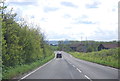
This page details the photographs taken nearby to Stoke Road, ME3 9NP by members of the Geograph project.
The Geograph project started in 2005 with the aim of publishing, organising and preserving representative images for every square kilometre of Great Britain, Ireland and the Isle of Man.

There are currently over 7.5m images from over14,400 individuals and you can help contribute to the project by visiting https://www.geograph.org.uk
Image Map
Images are licensed for reuse under creativecommons.org/licenses/by-sa/2.0
Notes
- Clicking on the map will re-center to the selected point.
- The higher the marker number, the further away the image location is from the centre of the postcode.
Image Listing (19 Images Found)
Images are licensed for reuse under creativecommons.org/licenses/by-sa/2.0
Image
Details
Distance
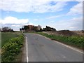
1
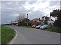
Tunbridge Hill, Stoke Road, near Hoo St. Werburgh
Image: © Chris Whippet
Taken: 5 Apr 2016
0.05 miles
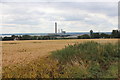
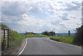
5

White Hall Farm and Wind Turbine
Farm shows eco-energy generating methods. As seen from footpath from Kingsnorth Industrial Estate to Stoke Road near North Street Farm.
Image: © David Anstiss
Taken: 9 Jan 2009
0.12 miles
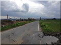
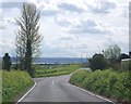
10
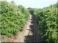
Freight line at Stoke Road
The line across the Hoo Peninsula is single track and one of the most interesting lines in Kent. Passenger trains ran on this line from 1882 to 1961, which seems surprising now as it doesn't really serve any significant centres of population. It is still in use by regular container trains on their way via Hoo Junction to and from Thamesport on the Isle of Grain. A train heading west over the level crossing at Grain can be seen at http://www.geograph.org.uk/photo/3603260
This is the view from Stoke Road. On the other side of the bridge behind me was once Beluncle Halt, named after a nearby farm. This was opened in July 1906 and was closed to passengers on 4th December 1961 See http://www.disused-stations.org.uk/b/beluncle_halt/index.shtml for more information on Beluncle Halt.
This view is looking towards Thamesport.
Image: © Marathon
Taken: 15 Aug 2013
0.19 miles