IMAGES TAKEN NEAR TO
Vidgeon Avenue, ROCHESTER, ME3 9DE
Introduction
This page details the photographs taken nearby to Vidgeon Avenue, ME3 9DE by members of the Geograph project.
The Geograph project started in 2005 with the aim of publishing, organising and preserving representative images for every square kilometre of Great Britain, Ireland and the Isle of Man.

There are currently over 7.5m images from over14,400 individuals and you can help contribute to the project by visiting https://www.geograph.org.uk
Image Map
Images are licensed for reuse under creativecommons.org/licenses/by-sa/2.0
Notes
- Clicking on the map will re-center to the selected point.
- The higher the marker number, the further away the image location is from the centre of the postcode.
Image Listing (2 Images Found)
Images are licensed for reuse under creativecommons.org/licenses/by-sa/2.0
Image
Details
Distance
1
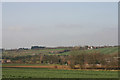
Open countryside west of Hoo St Werburgh
The Hoo Peninsula consists of a ridge of high ground between the Thames and Medway bordered by marshland to the north and east. Part of the ridge can be seen here rising to a height of around 65 metres.
Image: © David Kemp
Taken: 10 Mar 2012
0.23 miles
2
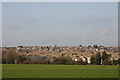
Hoo St Werburgh viewed from the south
A medium-sized village in living memory, post-War housing development has turned Hoo St Werburgh into something approaching a small town.
Image: © David Kemp
Taken: 10 Mar 2012
0.25 miles