IMAGES TAKEN NEAR TO
Vidgeon Avenue, ROCHESTER, ME3 9DD
Introduction
This page details the photographs taken nearby to Vidgeon Avenue, ME3 9DD by members of the Geograph project.
The Geograph project started in 2005 with the aim of publishing, organising and preserving representative images for every square kilometre of Great Britain, Ireland and the Isle of Man.

There are currently over 7.5m images from over14,400 individuals and you can help contribute to the project by visiting https://www.geograph.org.uk
Image Map
Images are licensed for reuse under creativecommons.org/licenses/by-sa/2.0
Notes
- Clicking on the map will re-center to the selected point.
- The higher the marker number, the further away the image location is from the centre of the postcode.
Image Listing (6 Images Found)
Images are licensed for reuse under creativecommons.org/licenses/by-sa/2.0
Image
Details
Distance
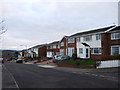
1
Hoo St Werburgh viewed from the south
A medium-sized village in living memory, post-War housing development has turned Hoo St Werburgh into something approaching a small town.
Image: © David Kemp
Taken: 10 Mar 2012
0.20 miles
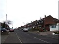
2
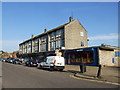
Shopping Parade, Knights Road, Hoo St. Werburgh
Image: © Chris Whippet
Taken: 5 Sep 2013
0.21 miles
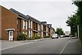
3
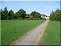
Recreation ground at Hoo St Werburgh
Hoo St Werburgh is one of the largest villages on the Hoo Peninsula and has far outgrown its original village centre. This is the recreation ground which seems to be the main park. The exit ahead is to Trubridge Road.
Image: © Marathon
Taken: 5 Sep 2013
0.23 miles