IMAGES TAKEN NEAR TO
Everest Drive, ROCHESTER, ME3 9AW
Introduction
This page details the photographs taken nearby to Everest Drive, ME3 9AW by members of the Geograph project.
The Geograph project started in 2005 with the aim of publishing, organising and preserving representative images for every square kilometre of Great Britain, Ireland and the Isle of Man.

There are currently over 7.5m images from over14,400 individuals and you can help contribute to the project by visiting https://www.geograph.org.uk
Image Map
Images are licensed for reuse under creativecommons.org/licenses/by-sa/2.0
Notes
- Clicking on the map will re-center to the selected point.
- The higher the marker number, the further away the image location is from the centre of the postcode.
Image Listing (160 Images Found)
Images are licensed for reuse under creativecommons.org/licenses/by-sa/2.0
Image
Details
Distance
1
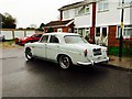
Vintage 1969 Rover P5, Everest Drive, Hoo St. Werburgh
Image: © Chris Whippet
Taken: 14 Nov 2015
0.02 miles

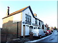
5
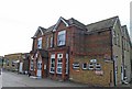
Hoo Institute
The foundation stone was laid by Mr G. F. Armytage in 1894. He was a local landowner. The building has been altered and extended but the centre section is close to original. At one time it was used by the Parish Council.
Image: © Martin Beale
Taken: 8 Sep 2008
0.04 miles