IMAGES TAKEN NEAR TO
Christmas Lane, ROCHESTER, ME3 8SW
Introduction
This page details the photographs taken nearby to Christmas Lane, ME3 8SW by members of the Geograph project.
The Geograph project started in 2005 with the aim of publishing, organising and preserving representative images for every square kilometre of Great Britain, Ireland and the Isle of Man.

There are currently over 7.5m images from over14,400 individuals and you can help contribute to the project by visiting https://www.geograph.org.uk
Image Map
Images are licensed for reuse under creativecommons.org/licenses/by-sa/2.0
Notes
- Clicking on the map will re-center to the selected point.
- The higher the marker number, the further away the image location is from the centre of the postcode.
Image Listing (21 Images Found)
Images are licensed for reuse under creativecommons.org/licenses/by-sa/2.0
Image
Details
Distance
1
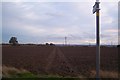
Footpath to the A228 Ratcliffe Highway
This path leads from Christmas Lane, across the field to a main road near Sharnal Street.
Image: © David Anstiss
Taken: 1 Nov 2009
0.05 miles
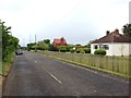
2
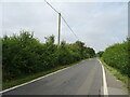
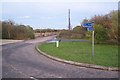
Christmas Lane
National Cycle Route 179 towards High Halstow.
Image: © JThomas
Taken: 23 Jun 2022
0.09 miles
4
Cycle track towards Christmas Lane
Old alignment of the lane by-passing a busy roundabout.
Image: © JThomas
Taken: 23 Jun 2022
0.14 miles
5
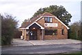
Christmas Lane Veterinary Surgery
On Christmas Lane, near Coach Barn Kennels and the A228 Ratcliffe Highway roundabout junction.
Image: © David Anstiss
Taken: 1 Nov 2009
0.15 miles
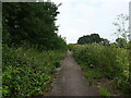
6
Cycle path near Christmas Lane
A cyclepath from High Halstow lead down a disused section of Christmas Lane towards the Ratcliffe Highway (heading to Grain) or Sharnal Street (heading towards Hoo). This section of road is now longer used due to a new roundabout on the highway.
Image: © David Anstiss
Taken: 1 Nov 2009
0.15 miles
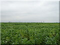
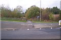
8
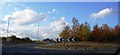
Roundabout near Sharnal Street
The A228 Ratcliffe Highway (from Grain) heads to the junction. It heads left to Hoo and to Strood and Chattenden. Christmas Lane leads straight on from the junction towards High Halstow and Cliffe. Sharnal Street is a small lane of houses leading left near the junction.
Image: © David Anstiss
Taken: 1 Nov 2009
0.18 miles
10
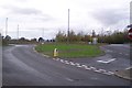
Cycle path crosses theA228 Ratcliffe Highway
A cycle path from Sharnal Street crosses the Highway (leading right to Stoke and Grain) to a disused road, then leading right to Grain or left to High Halstow.
Image: © David Anstiss
Taken: 1 Nov 2009
0.21 miles