IMAGES TAKEN NEAR TO
Clinch Street, ROCHESTER, ME3 8SP
Introduction
This page details the photographs taken nearby to Clinch Street, ME3 8SP by members of the Geograph project.
The Geograph project started in 2005 with the aim of publishing, organising and preserving representative images for every square kilometre of Great Britain, Ireland and the Isle of Man.

There are currently over 7.5m images from over14,400 individuals and you can help contribute to the project by visiting https://www.geograph.org.uk
Image Map
Images are licensed for reuse under creativecommons.org/licenses/by-sa/2.0
Notes
- Clicking on the map will re-center to the selected point.
- The higher the marker number, the further away the image location is from the centre of the postcode.
Image Listing (24 Images Found)
Images are licensed for reuse under creativecommons.org/licenses/by-sa/2.0
Image
Details
Distance
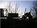
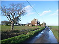
1
Clinch Street, near High Halstow
Isolated houses on Clinch Street, in countryside on the Hoo peninsula.
Image: © Malc McDonald
Taken: 23 Feb 2019
0.04 miles
2
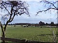
Horse paddocks at Walnut Tree Farm
Walnut Tree and Clinch Street farms stand high on the ridge which runs east-west between the Medway and Thames estuaries. Elsewhere along the ridge you can see one estuary or the other, but from around Clinch Street you can see both. The view here is SSE, with the chimney at Kingsnorth power station (on the Medway, TQ8172) visible on the skyline.
Until quite recently the Hoo (or Grain) Peninsula was a rough and ready sort of place, where the horses you saw were mostly in herds way out on the marshes, destined to end up as dog-food. The ones in the picture have no such worries.
Image: © Stefan Czapski
Taken: 9 Mar 2011
0.04 miles
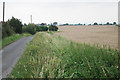
3
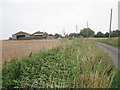
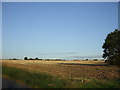
Walnut Tree Farm
Wheat field and farm along Clinch Street.
Image: © Oast House Archive
Taken: 29 Jul 2011
0.06 miles
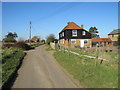
4
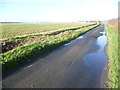
Clinch Street
After several days of heavy rain over Christmas and the New Year, the roads on the Hoo Peninsula were still waterlogged, and the surrounding fields were like quagmires. This is Clinch Street looking towards Clinchstreet Farm. Clinch Street becomes Decoy Hill Road before dropping down to Halstow Marshes.
Image: © Marathon
Taken: 2 Jan 2014
0.10 miles
5
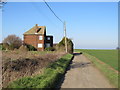
Clinch Street, near High Halstow
An isolated house on Clinch Street, on the Hoo peninsula in Kent.
Image: © Malc McDonald
Taken: 23 Feb 2019
0.11 miles
6
Looking along Clinch Street
After several days of heavy rain over Christmas and the New Year, the roads on the Hoo Peninsula were still waterlogged, and the surrounding fields were like quagmires. This is Clinch Street looking towards Walnut Tree Farm. Clinch Street becomes Decoy Hill Road before dropping down to Halstow Marshes.
Image: © Marathon
Taken: 2 Jan 2014
0.12 miles
8
Born Free......
There are two buildings in this picture, can you spot them?
Image: © Phillip Perry
Taken: 2 Oct 2008
0.17 miles
9
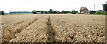
Wheat field by Clinch Street
Looking to Stout Farm.
Image: © Oast House Archive
Taken: 29 Jul 2011
0.17 miles