IMAGES TAKEN NEAR TO
Riverbourne Way, ROCHESTER, ME3 8GX
Introduction
This page details the photographs taken nearby to Riverbourne Way, ME3 8GX by members of the Geograph project.
The Geograph project started in 2005 with the aim of publishing, organising and preserving representative images for every square kilometre of Great Britain, Ireland and the Isle of Man.

There are currently over 7.5m images from over14,400 individuals and you can help contribute to the project by visiting https://www.geograph.org.uk
Image Map
Images are licensed for reuse under creativecommons.org/licenses/by-sa/2.0
Notes
- Clicking on the map will re-center to the selected point.
- The higher the marker number, the further away the image location is from the centre of the postcode.
Image Listing (84 Images Found)
Images are licensed for reuse under creativecommons.org/licenses/by-sa/2.0
Image
Details
Distance
1
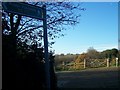
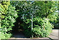
Footpath at end of Elm Avenue
Looking west towards Beacon Hill.
Footpath (RS127) passes a sports pavilion and small wind turbine, into wood.
Comes from Chattenden.
Image: © David Anstiss
Taken: 19 Nov 2008
0.05 miles

7
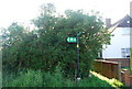
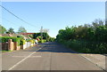
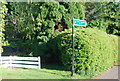
Saxon Shore Way sign, Elm Avenue, Chattenden
Image: © N Chadwick
Taken: 23 May 2010
0.08 miles
9
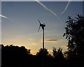
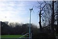
Elm Avenue Wind Turbine
On the edge of the woods and playing fields stands a single wind turbine towering above both trees and houses.
Image: © J Gregson
Taken: 10 Sep 2007
0.08 miles
