IMAGES TAKEN NEAR TO
Vestry Place, ROCHESTER, ME3 8FR
Introduction
This page details the photographs taken nearby to Vestry Place, ME3 8FR by members of the Geograph project.
The Geograph project started in 2005 with the aim of publishing, organising and preserving representative images for every square kilometre of Great Britain, Ireland and the Isle of Man.

There are currently over 7.5m images from over14,400 individuals and you can help contribute to the project by visiting https://www.geograph.org.uk
Image Map
Images are licensed for reuse under creativecommons.org/licenses/by-sa/2.0
Notes
- Clicking on the map will re-center to the selected point.
- The higher the marker number, the further away the image location is from the centre of the postcode.
Image Listing (60 Images Found)
Images are licensed for reuse under creativecommons.org/licenses/by-sa/2.0
Image
Details
Distance

4
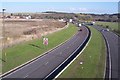
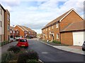
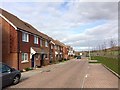
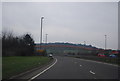
The A289 Dual Carriageway heading towards the A2/M2
This busy road leads from Chatham/Gillingham around Wainscott. It is heading towards the roundabout junction with the A288 heading to Grain. Liberty Park is a new housing estate on the edge of Wainscott. This seen in the background on the left.
Image: © David Anstiss
Taken: 22 Oct 2009
0.07 miles
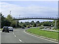
6
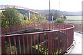
The footbridge over the A289
This bridge is on a path (No.RS125) leading from Wainscott Road to Upnor. It crosses over a busy dual carriageway.
Image: © David Anstiss
Taken: 22 Oct 2009
0.09 miles
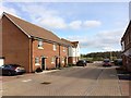
8
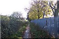
Footpath to Upnor
This path leads from Wainscott Road past Wainscott Primary School (fence on right) towards the A289 footbridge and then onto Upper and Lower Upnor.
Image: © David Anstiss
Taken: 22 Oct 2009
0.11 miles
9
The A289
The Medway Towns' northern relief road.
Image: © N Chadwick
Taken: 29 Jan 2011
0.11 miles