IMAGES TAKEN NEAR TO
Weymouth Road, ROCHESTER, ME3 8FF
Introduction
This page details the photographs taken nearby to Weymouth Road, ME3 8FF by members of the Geograph project.
The Geograph project started in 2005 with the aim of publishing, organising and preserving representative images for every square kilometre of Great Britain, Ireland and the Isle of Man.

There are currently over 7.5m images from over14,400 individuals and you can help contribute to the project by visiting https://www.geograph.org.uk
Image Map
Images are licensed for reuse under creativecommons.org/licenses/by-sa/2.0
Notes
- Clicking on the map will re-center to the selected point.
- The higher the marker number, the further away the image location is from the centre of the postcode.
Image Listing (62 Images Found)
Images are licensed for reuse under creativecommons.org/licenses/by-sa/2.0
Image
Details
Distance
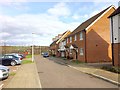
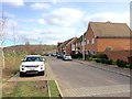
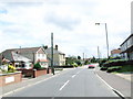
5
Hasted Road, Wainscott
From the bridge on Higham Road
Image: © David Howard
Taken: 19 Oct 2019
0.06 miles
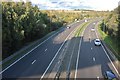
8
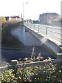
Higham Road Bridge over A289
High Road leads to Frindsbury from Higham.
A289 dual carriageway heads right to London/A2/M2, or left heading to Chattenden or Medway Tunnel.
Image: © David Anstiss
Taken: 19 Nov 2008
0.08 miles