IMAGES TAKEN NEAR TO
Bunters Hill Road, ROCHESTER, ME3 8ET
Introduction
This page details the photographs taken nearby to Bunters Hill Road, ME3 8ET by members of the Geograph project.
The Geograph project started in 2005 with the aim of publishing, organising and preserving representative images for every square kilometre of Great Britain, Ireland and the Isle of Man.

There are currently over 7.5m images from over14,400 individuals and you can help contribute to the project by visiting https://www.geograph.org.uk
Image Map
Images are licensed for reuse under creativecommons.org/licenses/by-sa/2.0
Notes
- Clicking on the map will re-center to the selected point.
- The higher the marker number, the further away the image location is from the centre of the postcode.
Image Listing (9 Images Found)
Images are licensed for reuse under creativecommons.org/licenses/by-sa/2.0
Image
Details
Distance

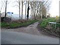
4
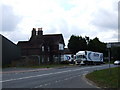
Road junction at Mockbeggar, near Strood
The blue sign beneath the "give way" sign indicates that this road is part of National Cycle Network route 1.
Image: © Malc McDonald
Taken: 7 Sep 2013
0.15 miles
5
Town Road, Mockbeggar
The B2000 heading towards Cliffe Woods.
Image: © Chris Whippet
Taken: 16 Jul 2009
0.17 miles
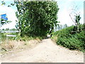
6
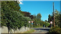
Common Road, near Chattenden
Common Road is a narrow country lane near Chattenden in Kent.
Image: © Malc McDonald
Taken: 23 Feb 2019
0.18 miles
8
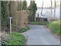
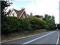
Bunters Hill Road, near Chattenden
This road is on the route of National Cycle Network routes 1 and 179. Route 179, named "The Heron Trail", was previously designated as regional cycle route 18.
Image: © Malc McDonald
Taken: 23 Feb 2019
0.21 miles
