IMAGES TAKEN NEAR TO
Dillywood Lane, ROCHESTER, ME3 8EN
Introduction
This page details the photographs taken nearby to Dillywood Lane, ME3 8EN by members of the Geograph project.
The Geograph project started in 2005 with the aim of publishing, organising and preserving representative images for every square kilometre of Great Britain, Ireland and the Isle of Man.

There are currently over 7.5m images from over14,400 individuals and you can help contribute to the project by visiting https://www.geograph.org.uk
Image Map
Images are licensed for reuse under creativecommons.org/licenses/by-sa/2.0
Notes
- Clicking on the map will re-center to the selected point.
- The higher the marker number, the further away the image location is from the centre of the postcode.
Image Listing (22 Images Found)
Images are licensed for reuse under creativecommons.org/licenses/by-sa/2.0
Image
Details
Distance
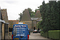
1
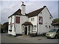
The Stone Horse Pub, Rochester
Dillywood Lane, Rochester, ME3 8EN near to the line of The Strood Canal Tunnels
Image: © canalandriversidepubs co uk
Taken: 5 Feb 2010
0.00 miles
2
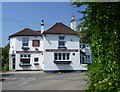
The Stone Horse pub, Dillywood Lane
The Stone Horse pub in Dillywood Lane is seen here from Stonehorse Lane.
Image: © Marathon
Taken: 6 Jun 2013
0.02 miles
3
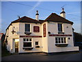
The Stone Horse
in Dillywood Lane at the junction with Stonehorse Lane. Confusingly, the map marks a Stone House Farm near here.
The local morris side came here in June 2006 http://www.flickr.com/photos/83753075%40N00/sets/72157594182546786/
Image: © Roger W Haworth
Taken: 7 Feb 2007
0.02 miles
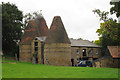
7

Oasthouse at Stone House Farm (3)
Seen here in an autumnal landscape - and the light is more subdued than when I was last here, at the end of winter http://www.geograph.org.uk/photo/2262923. Notice that the oasts have metal hoops around them, perhaps to prevent the brickwork from bulging - but the lower hoop on the right has snapped.
Image: © Stefan Czapski
Taken: 9 Oct 2011
0.06 miles
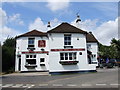
8
Stone House Farm
On Dillywood Lane.
Oast Houses on right are part of the farm.
Image: © David Anstiss
Taken: 19 Nov 2008
0.06 miles
9

Oasthouse at Stone House Farm (4)
Zoom shot taken from Stone Horse Lane. What might appear to be dark string-courses around the drum of the oast are iron hoops (or belts) - presumably needed to prevent the brickwork from bulging. Above the doorway is a black cast-iron plate, which appears to record the date of construction, and the names of those involved - but we were unable to read it at this range, even with binoculars.
For the building as it appeared on an earlier visit at a different season, see http://www.geograph.org.uk/photo/2262923.
Image: © Stefan Czapski
Taken: 9 Oct 2011
0.06 miles
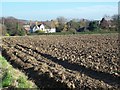
10

Oasthouse at Stone House Farm (1)
I have known these oasts for many years, but hadn't seen them for quite a while. I was pleased to find them pretty much unchanged. Not that I'm altogether against conversion - just that all too often the result is a bit prim, as if to deny the buildings' workaday history.
The lane where I stood to take this shot is known - quaintly - as Stone Horse Lane, and the pub nearby is the 'Stone Horse' - but then the name of the farm is Stone House Farm.
For a slightly closer view see: Image
Image: © Stefan Czapski
Taken: 8 Feb 2011
0.07 miles