IMAGES TAKEN NEAR TO
Lower Rochester Road, ROCHESTER, ME3 8EH
Introduction
This page details the photographs taken nearby to Lower Rochester Road, ME3 8EH by members of the Geograph project.
The Geograph project started in 2005 with the aim of publishing, organising and preserving representative images for every square kilometre of Great Britain, Ireland and the Isle of Man.

There are currently over 7.5m images from over14,400 individuals and you can help contribute to the project by visiting https://www.geograph.org.uk
Image Map
Images are licensed for reuse under creativecommons.org/licenses/by-sa/2.0
Notes
- Clicking on the map will re-center to the selected point.
- The higher the marker number, the further away the image location is from the centre of the postcode.
Image Listing (24 Images Found)
Images are licensed for reuse under creativecommons.org/licenses/by-sa/2.0
Image
Details
Distance

2
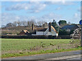
House, Sole Street Farm
A grade II listed building, early 16th century, extended later.
Image: © Robin Webster
Taken: 7 Feb 2014
0.03 miles
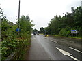
3
A289, Wainscott
Looking east from the bridge on the B2000.
Image: © JThomas
Taken: 23 Jun 2022
0.10 miles
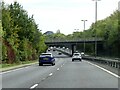
4
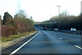
A289 eastbound
Lower Rochester Road, B2000, passes over ahead.
Image: © Robin Webster
Taken: 3 Feb 2019
0.10 miles
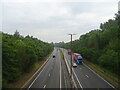
5
Rochester Roadbridge over A289
Rochester Road B2000 goes from Cliffe towards Frindsbury.
A289 dual carriageway underneath heads right to London A2/M2 or heads left to Grain or Medway Tunnel.
Image: © David Anstiss
Taken: 19 Nov 2008
0.10 miles
6
Hasted Road (A289) runs under Lower Rochester Road
Image: © Steve Daniels
Taken: 10 Oct 2020
0.11 miles
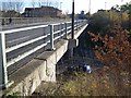
9
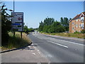
Lower Rochester Road
This is Lower Rochester Road at Wainscott at the junction with Hawkenbury Rise. The A289 just ahead is the main road to the Medway Tunnel, and the A228 leads off the A289 as the spine road across the Hoo Peninsula to the Isle of Grain.
Image: © Marathon
Taken: 8 Jul 2013
0.16 miles