IMAGES TAKEN NEAR TO
Kirk Lane, Cooling Street, ROCHESTER, ME3 7UR
Introduction
This page details the photographs taken nearby to Kirk Lane, Cooling Street, ME3 7UR by members of the Geograph project.
The Geograph project started in 2005 with the aim of publishing, organising and preserving representative images for every square kilometre of Great Britain, Ireland and the Isle of Man.

There are currently over 7.5m images from over14,400 individuals and you can help contribute to the project by visiting https://www.geograph.org.uk
Image Map
Images are licensed for reuse under creativecommons.org/licenses/by-sa/2.0
Notes
- Clicking on the map will re-center to the selected point.
- The higher the marker number, the further away the image location is from the centre of the postcode.
Image Listing (28 Images Found)
Images are licensed for reuse under creativecommons.org/licenses/by-sa/2.0
Image
Details
Distance
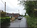
1
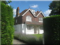
Bell Farmhouse, Cooling Street
Attractive farmhouse with lavender hedge.
Image: © David Anstiss
Taken: 2 Aug 2012
0.04 miles
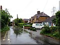
3
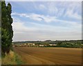
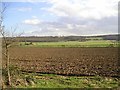
Farmland at Perry Hill
View towards Cooling Street, with Chattenden Woods in the distance.
Image: © Stefan Czapski
Taken: 16 Jul 2014
0.05 miles
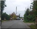
5
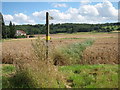
Footpath through wheat field by Cooling Street
Image: © Oast House Archive
Taken: 2 Aug 2012
0.08 miles
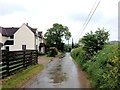
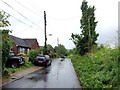
10
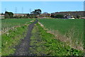
Footpath to Spendiff
The surface which appears at first glance to be cinders is in fact shredded automobile tyres.
Image: © David Martin
Taken: 25 Mar 2017
0.15 miles